
2.1.11 2021-02-20
- Fix creating offline map for paid multi-layer maps
- Share URL map definitions (in map edit screen)
- Android 10 support
- Fix Google search, directions and altitude
2.1.10 2020-03-21
- Fix double zoom-in when using the volume button
- Fix OpenStreetMap-based maps
2.1.7 - 2.1.9 2019-11-04
- Fix My Trails uploads
- The Kompass map is back
- Fix network access for most maps
- Fix crash on Android 9
2.1.6 2019-06-22
- Fix searching for location, directions, altitude normalization
- Fix connecting MyTrails to a Google account, switch to Firebase push
- Fix vertical speed in the HUD
- Fix remaining Wear notification after quit
- Fix GPSies
- New map: OpenSeaMap
- Fix receiving map definition from web site
2.1.5 2019-03-03
- Fix sharing tracks when the file is in an unexpected location
- Notifications and adaptive icon for Android Oreo
- Smarter max speed cutoff for GPS positions
- Replace Google+ with new MyTrails forum
- Fix IGN map
2.1.4 2018-07-07
- Fix opening maps.google.com URLs
- Warn when trying to record and MyTrails is not excluded from battery optimization
- Support Google's enhanced GPS when available (turn off in Preferences > Sensors)
- Fix OPNVKarte, Statkart, IGM, CalTopo, Google Earth and Terrain
- Provide fail-over IP addresses for license server (to work around Russian block)
2.1.3 2018-04-06
- Increase recording icons sizes
- Replace IDEE map with IGN for Spain
- Fix 4UMaps
- Make error reports opt-in as required by Play Store policies
- Fix track normalization
2.1.2 2018-02-02
- Fix StreetView
- Improve fullscreen mode, especially pre-Kitkat
- Removed personal data from error log collection to comply with Play Store policies, see updated Privacy Policy
2.1.1 2017-12-22
- Fix logging on and downloading communities
- Fix geoid lookup sometimes failing
- Fix importing tracks from downloads
2.1.0 2017-11-11
This new version is an almost complete rewrite of the UI code in MyTrails, keeping the same features of 2.0 (with some new features), but bringing MyTrails into the modern Android age.When I started developing MyTrails over 7 years ago, Android development was very crude, and developers had to include all sorts of work-arounds to add new features while still supporting Android 1.6, which was the version run by most phones at the time.
Over the years, I added features without being able to break from these work-arounds, until Nougat finally forced me to this rewrite (which I had fortunately started a few months in advance).
After 8 months of public preview and beta versions, 2.1 is finally here, with the following high-level features and hundreds of tweaks and fixes. I hope you enjoy it!- Nougat and Oreo-compatible
- New icons and refreshed look
- Waypoint manager
- Offer troubleshooting when GPS signal is lost
- Fix USGS maps
2.0.17 2017-07-02
- Removed LaTrace and RandoGPS, which are no longer available
- Improve Google maps
- Suggest upgrade to MyTrails 2.1 beta for Nougat
2.0.16 2017-01-09
IGN offline maps are available once more.2.0.15 2016-12-24
- Fixed tap to wake on dimmed screen
- Added zoom level 16 to OS Opendata maps (GB)
- Update current coordinates when following GPS
- Honor silent mode
- Fixed duplicate waypoints introduced in 2.0.13
- IGN slope maps (avalanche safety)
- Temporary fix for Nougat issue in Track list
2.0.13-2.0.14 2016-08-30
- New IGN (FR) subscriptions
- Fixed zombie waypoint dialogs
- Fixed Google Hybrid and Terrain
- Fixed incorrect altimeter before calibration
- Fixed UtagawaVtt integration
- Fixed track recording interruption in rare cases
- New Dropbox protocol (should be transparent)
- New maps (removed MapQuest)
2.0.12 2016-02-29
- Improved altitude recording
- Fixed lockup in paid online maps with slow connections
- Enabled double-tap-drag zooming (double-tap and hold, then move your finger up or down)
- Fixed altitude correction when offline
- MyTrails restarts the GPS when it stops providing data for too long
- Added Compass (free) and Formentera, Gran Canaria et Ibiza (premium)
- Fixed 4UMaps
- Added a Quit menu once more (optional)
2.0.11 2015-09-14
- Improved responsiveness of fast-changing stats like compass bearing and GPS satellites
- Fixed saving the track color into GPX
- Added support for deleting tracks (not just forgetting them)
- Increased max cache size option
- Added facing indicator when not moving
- GPS altitude filter and option for cumulative climb tweaks
- Fixed Utagawa and RandoGPS track download
- Many translation updates, many thanks to my translators!
- Improved directions dialog
2.0.10 2015-02-06
- Fixed importing tracks without timestamps
- Improved time stats
2.0.9 2015-02-05
- New, simpler track recording UI (activate in Preferences > Recording)
- MyTrails reminds you to save the track when you're back at your starting point
- Use tags to organize your tracks and waypoints
- Look for nearby place names to help name tracks and waypoints
- Fixed tapping on track; track details now shows information about the tap location and offers to create a waypoint
- 10 new stats (duration, distance and number of climbs and descents)
- 1 new graph (filtered speed)
2.0.8 2014-12-19
- Removed READ_PHONE_STATE permission, added without my knowledge by a bug in the Android build tools
2.0.7 2014-12-17
- On devices without a compass, the compass button is replaced with a travel direction arrow and the map can still be aligned to the travel direction
- New HUD options: black background, less-cryptic labels (but smaller value display)
- Improved detection of external SD cards
- Tap the GPS dot (or the cross at the center of the screen when not following GPS) to create a new waypoint there
- File selection: options to sort folders before files, hide .hidden files
- Bug fixes
- Many translation improvements, especially for Russian
2.0.6 2014-12-04
- Fixed Google Earth
- Removed Yahoo (the old Yahoo tiles are no longer available and the new service uses a protected HERE API)
- Optimization and fixes for map tile display
- Fixed inability to create offline OS25k-only maps
- Fixes and optimizations for WMS maps
- New option to hide automatic waypoints (pause and altimeter)
- Added support for using voice search: "Ok Google, search for Paris using MyTrails" (English-only until Google starts to support other languages)
2.0.4 & 2.0.5 2014-09-29
- Define offline maps from maps.frogsparks.com/define_map.jsp so you don't have to fiddle on your phone
- Send as SMS works with Hangouts
- Fixes for offline and WMS maps
- Many small fixes and adjustments
- 2.0.5: default language and missing voice data dialog fixed
2.0.3 2014-08-05
- New track sharing community: RandoGPS (French focused)
- Added option to search for location in OSM and IGN (French, requires online subscription)
- Easy way to retry failed purchases (in Preferences > About > Retry purchase)
- Bug fixes
2.0.1-2.0.2 2014-07-18
- Android Wear support!
- Android L adjustments
- Bug fixes (in particular, problem in Preferences on Gingerbread)
- More options for flexible URL map definitions
2.0.0 2014-07-07
After over a year of development, MyTrails 2 is finally ready for general release. There are a lot more changes than can be documented in the normal style of release notes, and most areas of MyTrails have been upgraded or are completely new.Updated look
From the transparent action and status bars, to the slide-out navigation menu, to the new track manager, MyTrails uses the latest in Android interface elements.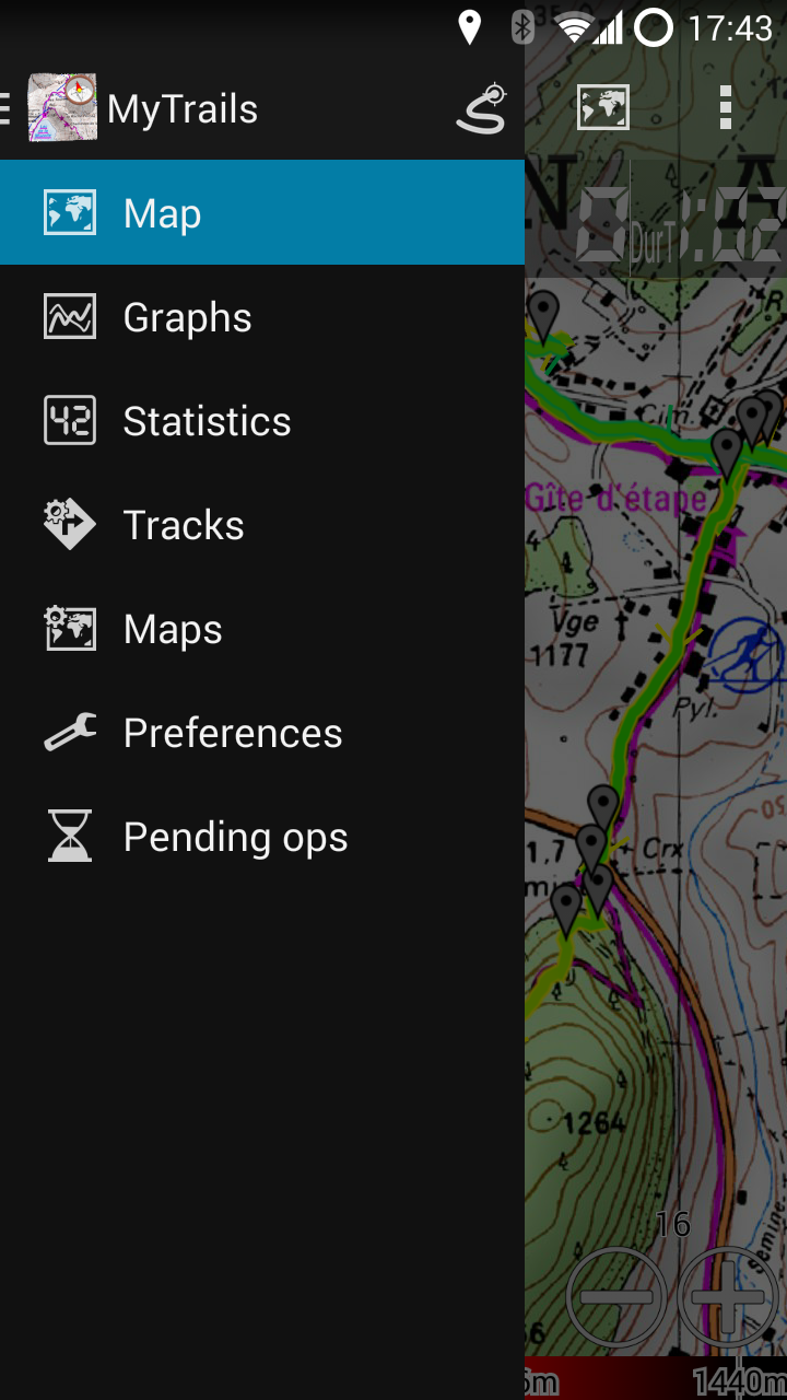 The slide-out navigation menu: quick access to all features[/caption]
 Transparent status, action and nav bars blend seamlessly into the map[/caption]
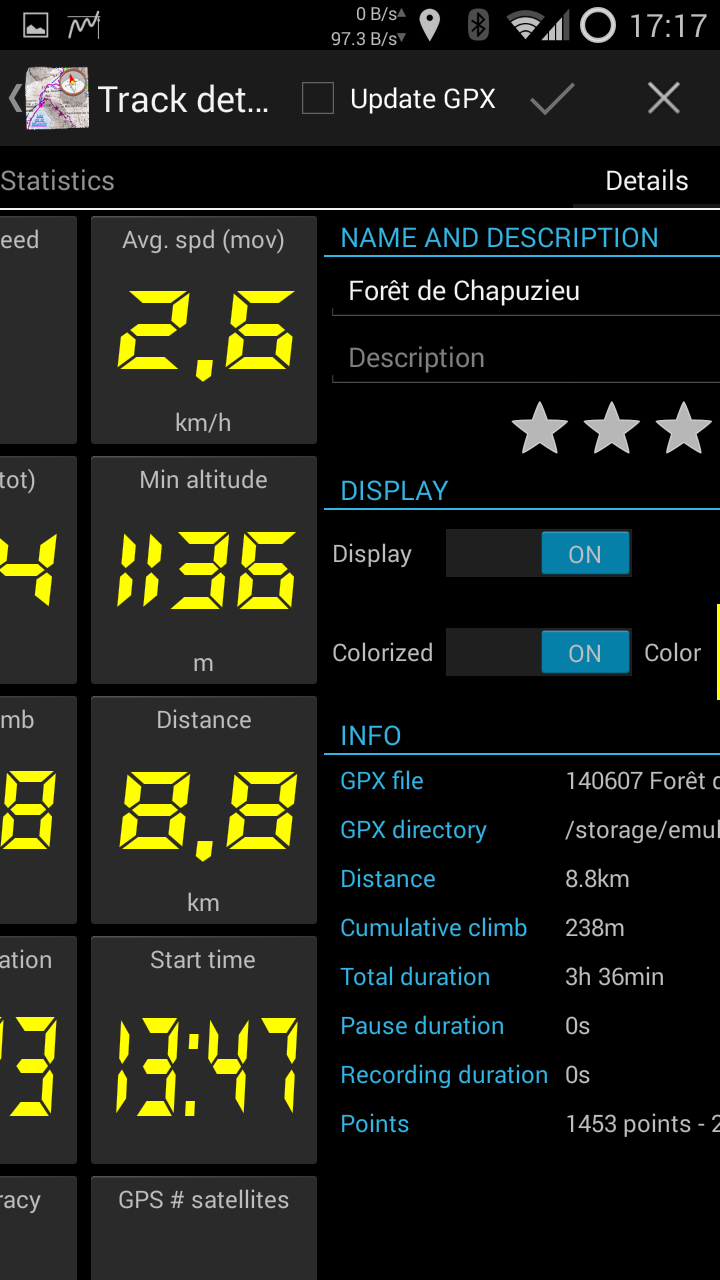
Stats
MyTrails is now able to display in real-time more than 40 stats about your saved tracks and the current recording. From much-requested stats like cumulative climb to obscure ones like average slope during a descent, you can quantify many aspects of your tracks. And these stats can be displayed for multiple recordings in parallel. You can select any of these stats (up to 5) to display in the HUD on the main map view.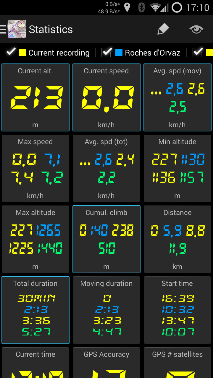 Create your own dashboard[/caption]
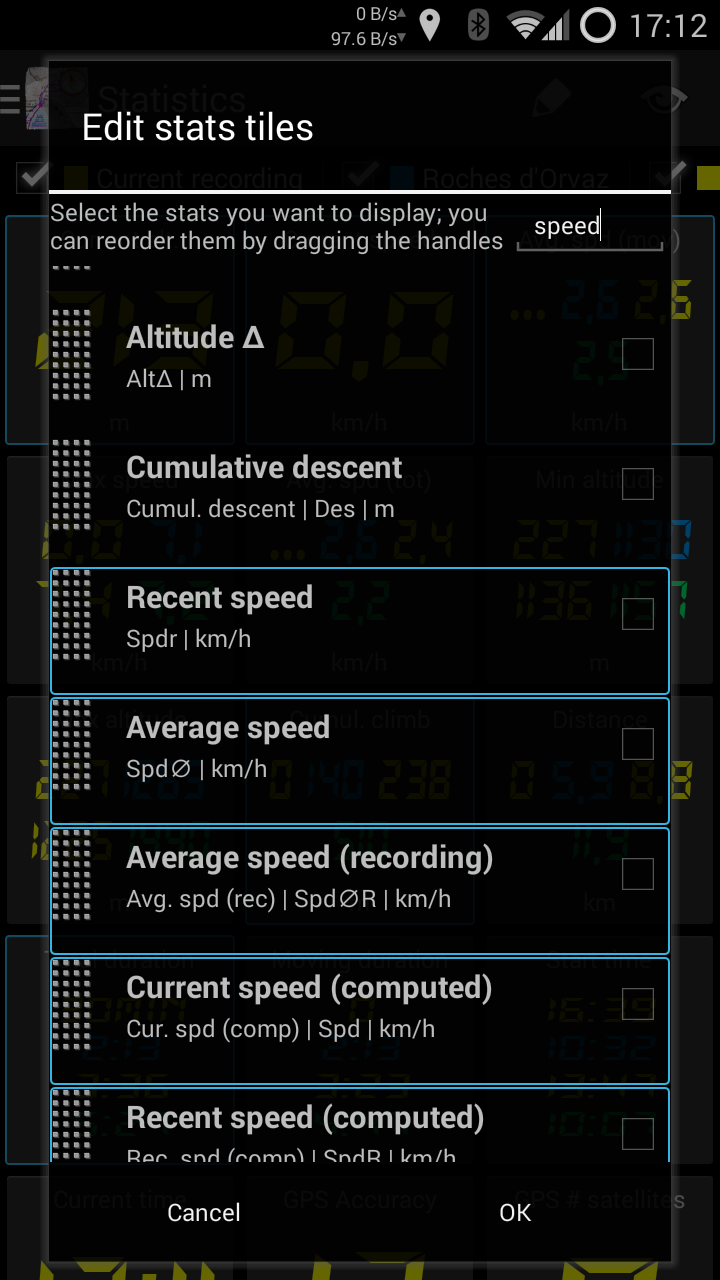 Over 40 available metrics[/caption]
Graphs
While stats provide a synthetic view of many variables, graphs give you a better view of how these variables evolve over time. And again, you can compare saved tracks against your current recording. [caption id="attachment_2587" align="aligncenter" width="168"]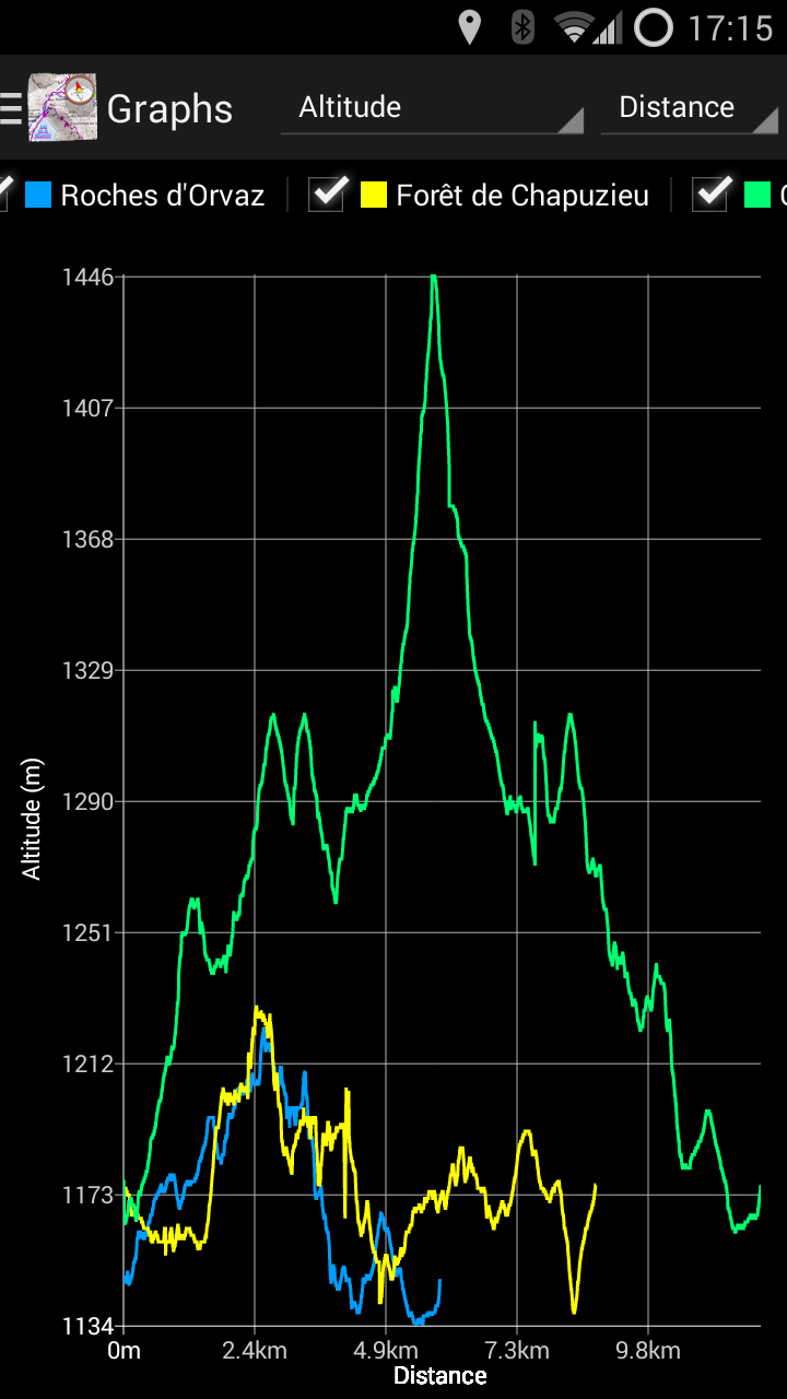 Select the tracks and axes freely[/caption]
Track manager
The new track manager makes it easier to visualize your tracks without necessarily activating them: view general information, stats and graphs, and even the shape of the track, or multiple selected tracks. Download, share, upload multiple tracks at once, and much more!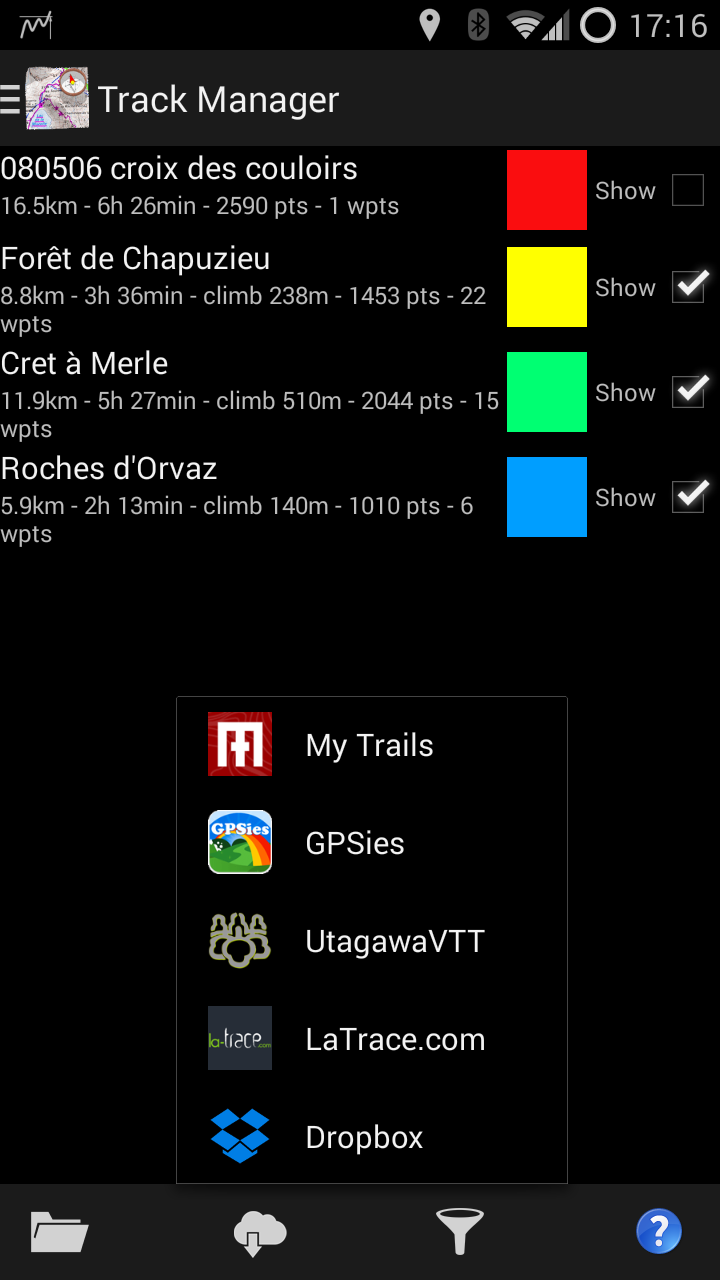 Organize your tracks, upload, download, etc.[/caption]
 A 4-pane view of the track's graph, stats, properties and map[/caption]
Altimeter
MyTrails can now use your device's pressure sensor, which can be much more accurate than the altitude provided by the GPS. For the most accurate results, you can calibrate it manually, or just let MyTrails auto-calibrate. [caption id="attachment_2590" align="aligncenter" width="168"]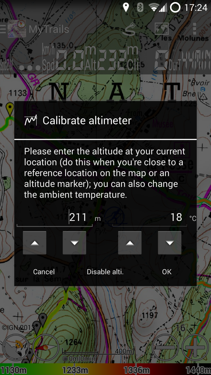 Manual or automatic calibration[/caption]
Minimum version
Since one of the principles of MyTrails has been to provide good performance even on basic hardware, I have supported old versions of Android for a lot longer than I should have. MyTrails 2 only supports Android 2.3 and later. I will continue to update MyTrails 1.4 occasionally for bug-fixes and map compatibility, but all new features will only be available in MyTrails 2.Gallery
[gallery ids="2579,2578,2590,2589,2588,2587,2586,2585"] [raw_html_snippet id="features-gallery"]1.4.7 2014-05-15
- Updated Mapquest map
- Force MyTrails to quit in a timely manner, even if Android wants to wait a bit
- Removed halo around outlines (in HUD, scale, etc.)
- Slight increase in map rendering speed
1.4.6 2014-03-31
- Updated API to invoke MyTrails Contacts
- Fixed occasional flickering of tiles loaded from the network
- Fixed GPSies upload for some tracks
- License checking is more tolerant of network failure
- Added two options: Fallback distance calculation and Don't warn of GPS errors, that were previously hidden options
1.4.5 2014-03-11
- My sincere apologies to users who had trouble activating the App of the Day promotion; if you haven't yet activated the promotion, this version should do it for you automatically
- You can now follow us on Facebook
- Fixed reported errors
1.4.4 2014-02-26
- Fixed startup crash on Android 2.2
- Improved compatibility with some WMS servers
1.4.3 2014-02-06
- Improved track drawing
- Fixed total recording time calculation
- Improved time and distance colorizations (dashed): when the recording quality is insufficient or map zoomed out too far, the colorization is disabled
- Support creation of extremely large offline maps ('toggle bigger mgm' hidden option)
- Easier waypoint selection: tap the point or body
1.4.2 2014-01-13
- Google forbids offline download for their maps
- Fixed purchase experience for T&T maps
- Ordnance Survey maps are no longer available for sale
1.4.1 2013-12-20
- New track rendering algorithm, much more eye-pleasing
- New Ordnance Survey map subscriptions (1/2 prices in some cases)
- Integration with Google account as a simpler alternative to FrogSparks account, where available
- The Pro license is now available as an in-app purchase tied to the FrogSparks (or Google) account, so it is honored on any platform
- Fixed HUD rendering on KitKat
MyTrails available on Amazon Appstore 2013-11-29
Many MyTrails users have a phone they take with them on outings, and they would like to be able to plan their itinerary and view the recorded track on their Kindle, which stays safely at home. Until now, this was made more difficult by the fact that while MyTrails could be side-loaded on the Kindle, there was no good way to get the Pro version working on Kindle. And some people rely on Kindles exclusively. So in a few days, once it passes Amazon's validation process, MyTrails will be available on the Amazon Appstore, with the following changes:- New track rendering algorithm, much more eye-pleasing
- Integration with Google account as a simpler alternative to FrogSparks account, where available (also log in to maps.frogsparks.com with your Google account)
- MyTrails is now available on Amazon Appstore
- The Pro license is now available as an in-app purchase
- Like maps, the Pro upgrade is tied to the FrogSparks (or Google) account, so it is honored on any platform
1.3.24-1.3.26 2013-10-14
- New map: VTTrack-ST (single-track layer map)
- New colorizations: distance and time
- Layer maps can be taken off-line
- Show disabled GPS icon when no data is received from the GPS
- Screen lock no longer engages while using a dialog (only on Android 4.2 and later)
- File upload progress is more regular
- 2.1 work-around for IGN is no longer necessary
- GPSies: download your own private tracks
1.3.23 2013-08-09
- Fixed IGN Littoral and satellite
- Worked around an Android bug for distance measurements on some phones
1.3.21 2013-07-18
- Fixed slowness and old imagery for Google Maps and Satellite
- Changed error and logging provider to no longer rely on Android logging
- Direct loading of VisuGpx.com tracks
- Improved parsing of GPX
- Layer maps: upscale bottom map if it maxes out at a lower zoom level than the top
- Added new IGN SCAN Express maps (vector-based topo maps)
- Fixed downloading from Dropbox
1.3.18-1.3.20 2013-06-17
- New map type: Layer maps (transparent layers: create in Map Manager > Add, then configure layers)
- More flexible IGN subscriptions: Top100-only, on- and off-line combo subscription
- Offline download: automatically resume download if it was interrupted by Wifi disconnect
- Fixed missing speed in HUD when device clock is off
- Improved map deletion
- Fixed flickering with IGN maps configured with a fallback
1.3.19 and 1.3.20 are emergency bug fixes. Sorry for the trouble.
1.3.17 2013-05-15
- Refreshed icons, added high resolutions icons
- Fixed Dropbox authentication (API changed)
- Improved compatibility with WMS 1.3.0 servers
- On Android 3.0 and later, the cache is now stored on the main storage (not sdcard)
- Added the ability to force the language
- Fixes for reported issues
- Added a work-around for IGN maps on some Android 2.1 and earlier devices
- Added a warning of possible GPS unreliability if temporal resolution is greater than 1s
1.3.16 2013-04-18
- Added IGN Littoral and IGN "satellite" photography (premium maps)
- Map1.eu map (a very pretty OSM-based map, please support the author)
- Added la-trace.com as a track sharing community (download-only)
- Fixed sticky notification when canceling an offline download
- Added support for basic authentication for WMS servers; improved feedback
- Fixed list of communities available for upload (restores Dropbox upload)
- Added optional check for beta versions
- Implemented lightweight analytics (disable update checks to prevent data from being sent)
1.3.15 2013-04-03
- Added UtagawaVTT as a track sharing community (download-only)
- Added support for viewing StreetView (long-tap the map)
- Tweaked the map icons and scale for better readability
- Added legend view for IGN maps (long-tap the map)
- Fixed reading manual
- Use .noscanandnomtp to prevent indexing of cache by Media Scanner (CM only)
1.3.14 2013-03-25
- Fixed corrupted tiles on startup with Google Earth and Terrain and incorrectly high zoom for Terrain
- Fixed too-low average speed in HUD
- Fixed occasional flicker when loading failed
- Fixed issue with offline Yandex maps
- Improved offline download to prevent Android from interrupting
- Added support for Samsung multi-window
1.3.13 2013-02-22
- Fixed a crashing bug when tapping the scale LED
1.3.12 2013-02-21
- Fixed map flashing on pre-Honeycomb devices when turning the screen off, then on
- Catch some device-specific crashes
- Fixed target waypoint getting confused when zooming in a lot
1.3.11 2013-02-14
- Fixes for reported issues (mainly offline downloader and widget)
- Fixed a possible battery drain when MyTrails is running but not recording and the screen turns off
Sorry for the quick succession of updates.
1.3.10 2013-02-11
- Bigger map buttons to better conform to Android guidelines
- Warning when the GPS somehow stops recording
- Offline downloader shows previously-downloaded areas
- Sharing after upload includes a track screenshot and works with Twitter, Facebook and G+
- EXPERIMENTAL lockscreen widget (also works on homescreen)
- HUD computes average speed as distance / time spent moving
- Improved display performance even further and fixed the blurry scale that affected some devices
1.3.9 2013-01-11
- Minor fix for GB Grid Reference formatting
- Restored the track arrows (they were broken in a previous update)
- Made tracks more visible on extra high-density devices
- Fixed difficulty in selecting offline download area in some cases
1.3.8 2013-01-07
- Added Toporama map (CA)
- Better feedback during map purchase, more safeguards during FrogSparks account creation
- Fixes for reported errors
- Fixed saving traces to the root of the Dropbox account
This version was released in a bit of a rush due to an issue with Google's now publisher console, I apologize in advance for any bugs.
1.3.7 2012-12-07
- Improved area selection for offline download (ability to move area)
- Improved map buying experience (purchase success is now more obvious)
1.3.6 2012-11-12
- IGN France maps can now be purchased
- Ability to edit the coordinates of waypoints and convert between coordinate formats
- Cleaned up coordinate handling and made the parsers more tolerant
- Added IGM maps for Italy (unfortunately slow and with a big watermark)
- Improved Pending Operations when multi-tasking
1.3.4 2012-10-18
- Jellybean expandable notifications
- Streamlined the process of creating premium offline maps when not subscribed to the premium online map
- Fixes for reported issues
- Polish translation updated by Tomasz (thanks!)
1.3.3 2012-10-02
- Added ability to resave the GPX when editing a track's name or description
- Added support for sending a tweet when a track is uploaded (only GPSies and My Trails); this has been tested with the web browser, the official Twitter client and Twicca, but does not yet work with Plume, TweetDeck or TweetCaster
- Fixed MyTrails freezing when trying to clear the track right on launch
- MyTrails can now continue to record the track if the phone reboots while a recording is in progress
- Improved support for geo intents (using MyTrails from the address book)
- Fixes for reported issues
1.3.2 2012-09-24
- Fixed Italian and Portuguese translations that were causing crashes
- Fixed a possible crash when clearing the track
1.3.1 2012-09-20
Small fix for in-app map purchases.
1.3.0 2012-09-20
It's been a lot longer than I would have preferred, but it's been a good occasion to rework some pretty complex logic in the core of MyTrails' track handling. Based on this version, adding support for graphs will be much easier, and that will be the focus of the next few releases.
- Changed the way tracks are handled
- Break detection: a new track segment will be created if the recording is paused or the track is otherwise interrupted
- Fixed an issue where long tracks under high zoom sometimes caused rendering artifacts
- GPX track segments supported (save and load)
- Added support for track arrows, little legs on the sides of tracks that show the direction of travel
- IGN map
- Now uses Geoportail-hosted maps
- Added support for IGN Cadastre maps
- Dropbox
- Moved to v1 API, which changes how MyTrails handles Dropbox authentication
- Allow overwriting a track
- Screen lock option allows MyTrails to ignore all input (except Home button) after a few seconds (Pro)
- Added support for opening locations in MyTrails (geo intents)
- Added an LED to the scale to denote the recording status and easily toggle recording
- Added recording and displaying of raw speed from the GPS (there is no standard for storing speed in GPX)
- Added an option for an even heavier compass filter
- Updated maps
- WanderReitKarte (now a single-layer map on the server)
- OutdoorActive (new URL)
1.2.43 2012-07-06
- Improved display of GB grid references and DMS coordinates
- Fixes for reported issues
I'm concentrating on 1.3 at the moment, so expect few updates to 1.2.x. The initial version of 1.3 should be available within a few weeks. Please contact me if you'd like to be part of the beta.
1.2.42 2012-06-21
Apologies for releasing an update so soon after 1.2.41; this release fixes an issue when MyTrails adds tiles to an existing offline map, so I wanted to release it as soon as possible.
- Fixed corrupted tiles in some offline map downloads when downloading to an existing map
1.2.41 2012-06-20
- Added an option to draw the map at a screen resolution-independent size (very high density displays like Galaxy Nexus and Galaxy III made the map hard to read)
- Added the ability to display the map larger while staying on the same zoom level (long-tap the zoom buttons)
- Improved offline download: interrupted downloads can be easily restarted, better feedback
- Fixed creating offline Yandex maps
- Added TopOSM map (US)
- Added ability to use GB grid references with 4, 6, 8 or 10 digits
1.2.40 2012-06-05
A quick fix to address two issues I was finally able to reproduce when I received my new Galaxy S III.
- Fixed missing map selection menu on some ICS phones
- Fixed occasional issue where tiles would no longer load
1.2.39 2012-05-31
Sorry for the delay since the last version was published! This year most of the weekends in May were prolonged by bank holidays, so the work-weeks ended up being pretty short. Also, I lost a whole week to a hospital stay (everything fine now). Anyway, I'm once again working full steam on new features and improvements.
- Send waypoint or coordinates via SMS (to receive them, install MyTrails SMS plugin from Play Store)
- Share track via email
- Added 4UMaps, OSM-based maps optimized for hikers and bikersn
- Added decimal minute coordinate format
- Fixed issue with the GPS location marker on Yandex maps
- Fixed track timestamps for tracks longer than 24 days (from when the track was initialized)
1.2.38 2012-04-26
- Added Mapquest, osmapa.pl and NZtopomaps
- Improved the license verification process to be more tolerant of failures to connect to Google's servers
- Fixes for reported issues
1.2.37 2012-04-11
- Added Tour & Trail maps, a collection of premium maps covering popular tourist destinations in Spain and Portugal; try the free Graciosa map
- Added altitude correction (if available, based on NMEA, if not, via online lookup)
- Added a dedicated section for premium maps
- Offline download improvements (fallback maps are now used)
- Extended trial period for most premium maps to a week or 5 sessions
- Fixed rounding error in OSGB grid references
- Updated MyTrails.com.au API
- Removed Nearmap (now secured), Sigpac (offline), Osmarender (offline); fixed DoCeLu
- Fixes for reported issues
1.2.36 2012-04-03
- Fixes for reported issues
1.2.35 2012-04-02
- Offline support for premium maps; offline premium maps may be "secure" (required by providers), which means they can be used only with an offline subscription and can not be used in other applications
- Improved offline downloader (streamlined UI)
- Safer map deletion
- Italian translation (thanks Daniele!)
1.2.34 2012-02-24
- Fixes for reported issues
Older versions 2012-02-12
Version 1.2.33 (12-02-23)
- New URLs for OpenPisteMap (and better zoom)
- Fixed crash when getting directions
- Added MyBackup support, so that non-root users can perform backup and restore of MyTrails settings and data (install from the Preferences > About screen)
- Fixes for reported issues
Version 1.2.32 (12-02-16)
- Better filename validation for saved tracks
- USGS was sometimes not added
- Added Frogsparks account, which allows you to use map subscriptions on all your devices (you need to log in from each device)
- Added look for > coordinates to jump to a coordinate
- Added support for GB National and US Military grid coordinates
- When displaying coordinates and the map is not centered on the current location, a reticule is drawn matching the coordinate display
Version 1.2.31 (12-02-12)
- Ordnance Survey 25k and 50k map for GB! This is a premium map that requires a specific in-app purchase (Pro not required)
- MyTopo (US/CA) is no longer available, and is replaced with USGS (US only)
- More new maps: Cassini (FR, historical) and Sigpac (ES)
- Flexible WMS support: thousands of supported map providers
- Test version of IGN top25 and top50 map for France. Also a premium map, not yet available for purchase
- Fixes for reported issues
Version 1.2.30 (12-02-03)
- Fixes for reported issues
Version 1.2.29 (12-01-30)
- Enabled 2-step overzoom (previously only 1-step)
- Start an offline map download by long-pressing the main map to select one edge of the area and drag to the opposite edge
- The scale is updated when the latitude changes (since it's latitude-dependant) and is not displayed at all when zooming out
- Major performance improvements (especially on tablets): improved tile loading speed, memory management and caching (the cache will be reset on first run)
- Added Portuguese translation (thanks Jose!)
Version 1.2.28 (12-01-16)
- Improved tile loading speed (by as much as x6 on some configurations)
- Much improved UI to select the area for offline download (including ability to enter coordinates in DMS or UTM format)
- Added update checking for non-Market users
- Added option to display the GPS coordinates on the map (Pro only)
- Fixes for reported issues
Version 1.2.27 (12-01-05)
- GPSies: fixed the public flag being inverted
- Fixed Google Terrain maps and added auto-detection
- Fixed an issue with getting directions in some countries
- Started using BugSense
- Updated French translation
Version 1.2.26 (11-12-13)
- Deferred network usage: uploading a track to an online community and normalizing a track's altitude can be queued and executed later
- Added an option to not upload automatically detected pauses to GPSies (to reduce clutter)
- Added a visual timer for sticky GPS
- Improved the offline tile download process to better handle slow tile providers
- Detect incorrectly set saved tracks location
- Fixes for layout issues on HD screens and xhdpi densities
- Added an option to keep the screen on full brightness
Version 1.2.25 (11-11-30)
- When switching maps by swiping, the map name is briefly displayed
- Fixed crashes on quit that were introduced in the last version
- Improved the layout of the large buttons
Version 1.2.24 (11-11-23)
- Added the ability to create waypoints with default values (will use the same values as previously created waypoints for track and color)
- Improved quitting the application: double-tap back to shut down the tracker
- Added a preference to quadruple the size of the zoom buttons, for bikers
Version 1.2.23 (11-11-10)
- Improved offline map downloader to support a daily limit for providers that send placeholder tiles in cases of abuse
- Fixed an issue where offline downloads would stop and need to be restarted in cases of errors with multi-layer maps
- Fixes for reported issues
Version 1.2.21 (11-10-21) and 1.2.22 (11-10-24)
- Multi-layer maps: Google, Yahoo and Eniro hybrid maps are now supported
- Added a new OSM-based (3-layer hybrid!) map: WanderReitKarte
- Tweaks for Ice Cream Sandwich
- Added Lonvia.de maps (2 layers)
- Fixes for reported issues
Version 1.2.20 (11-10-18)
- Added new map source for the UK: OS Opendata. This is a premium map, for which a subscription is required. Not OS 25k and 50k yet...
- Added progress bar to file uploads (My Trails, GPSies, Dropbox)
Version 1.2.19 (11-10-14)
- German translation updated (thanks Ansgar!)
- Fixed Yahoo maps, but Yahoo hybrid now use layers, so they no longer work (until MyTrails supports layers)
- Fixes for reported issues
Version 1.2.18 (11-09-22)
- Optimized drawing: zooming and panning should be even smoother now
- Fixed normalizing altitude of tracks that didn't have altitude data
Version 1.2.17 (11-09-15)
- Added altitude normalization (Pro) in the track manager (for saved tracks): uses an online service to correct altitude for GPS tracks
- Improved offline map generation: the map can now be used even before the download is complete, and a new download session can be added to an existing offline map
- Improved pinch-zooming
- Improved GPX saving and loading: MyTrails-specific data (waypoint color, etc.) is retained
Version 1.2.16 (11-09-09)
- First Honeycomb-optimized version (not all dialogs are optimized yet)
- Version info is no longer shown on each startup
- Fixed an issue introduced in .15 where exported GPX were incorrect if they included waypoints
Version 1.2.15 (11-09-07)
- Google Earth maps should now automatically use the latest data
- Removed Cyklolatlas maps, as they are now protected by a dynamic authorization scheme
- Added look for > waypoint to easily center a waypoint
- Added option in waypoint context menu to download offline map around the waypoint
- Removed offline help file for a lighter install (online help is still available)
- Fixes for Honeycomb tablets: better memory allocation, fixed issue with tracks sometimes not displayed
Versions 1.2.9 to 1.2.14 (11-08-11 to 11-08-24)
- Pause detection: stops recording the track when the device is stationary, until it leaves the area
- MyTrails now reports the time spent recording the track (excludes time when GPS is off) and pause time (tap the scale to display)
- Removed OS maps (UK) following a request by the rights holders
- Added preference shortcut to minimize power drain
- Moved zoom indication to zoom buttons and changed zoom icons
- Added preference to prevent MyTrails from keeping the screen on
- Fixed importing GPX from attachments
- Reworked map manager so that future map updates are less intrusive (only updated maps are changed)
- Fixed Yandex and docelu.pl maps
- Fixes for reported issues
Version 1.2.8 (11-07-25)
- Added option to disable compass after a few seconds when not using compass orientation (useful for long trips with screen on)
- HUD is refreshed when coming to a stop
- Added option to draw a line to the next waypoint (must be manually selected)
- Added higher-visibility mode (replaces larger scale option)
- Upgraded issue reporting system to ACRA 4
- Track uploads to MyTrails.com.au are now gzipped to save bandwidth
- Improved offline downloader to be more error-tolerant (and keep the screen on to speed download)
- Fixed touch-related crashes on Honeycomb
- Fixes for reported issues
Versions 1.2.6 and 1.2.7 (11-07-05)
- Dropbox upload and download of tracks
- Fixed MyTopo in such a way that upcoming changes on the MyTopo server will be detected automatically
- Added an option for higher friction when the map is flung, consistent with Google Maps
- Compass now works even when the phone is not horizontal
- The HUD is no longer pixelated on small screens (320x240)
- Fixed offline download feedback and notifications
- Added Dutch (thanks Maurits!)
- Fixes for reported issues
Versions 1.2.5 (11-06-14)
- Fixes for reported issues
Versions 1.2.4 (11-06-09)
- Track sharing communities: added GPSies
- Moved contact lookup into a separate application so that MyTrails no longer relies on READ_CONTACTS permission
- Fixed offline map generator downloading too many tiles
- Added preferences to reduce the memory usage of tracks for long trips
- Added ability to select how saved tracks are named
- Added map provider: OpenHikingMap
- Improved several screens in landscape
- Fixed proximity notifications for very slow speeds (walking)
- Fixes for reported issues
Versions 1.2.3 (11-05-26)
- Track sharing communities: upload to, search and download tracks from MyTrails.com.au (more to come)
- Fixed GPS tracking not starting in certain cases
- Added ability to open GPX attachments in emails and GPX files from file browsers
- Clarified pause/continue recording and added a dedicated Start new recording option
- Fixed Yandex Map and Satellite, Google Satellite
- Fixes for reported issues
Versions 1.2.2 (11-05-16)
- Fix for scale display on small screens
- Fixed saved GPX when waypoint names or descriptions include invalid XML
- Fixed waypoints appearing after the corresponding track is deleted
- Many FC fixes, sorry for the trouble
Versions 1.2 and 1.2.1 (11-05-11)
- Waypoints: add, edit, read from GPX, write to GPX; Waypoints can belong to a track or not, and they be of different colors
- Directions: create a track providing directions between two locations
- Proximity warnings: vibrate, ring and/or speak the name of the upcoming waypoint (Pro only)
- Improved memory management
- Changed sticky GPS delay to 15s rather than 5s
- If the screen is dimmed, MyTrails ignores the first tap
- Reorganized main menu to better separate current recording from other tracks
- When traveling at speed > 10km/h, the GPS dot is replaced with an arrow indicating direction of travel
- Option to use GPS direction of travel for orientation instead of compass
- Magnetic declination correction
Versions 1.1.4 (11-04-15)
- Search no longer crashes on pre-FroYo devices
Versions 1.1.3 (11-04-13)
- Fixes for reported issues
Versions 1.1.2 (11-04-08)
- Search improvements: works on all devices, added ability to search for contacts, added search history
- Edit name and description of loaded tracks
- Offline map creation: better feedback during download
- Fixes for reported issues
Versions 1.1.0 and 1.1.1 (11-03-30)
- Map manager
- faster and more robust
- added ability to reorder maps and hide maps from the map selection dialog
- added many more maps (including Google maps)
- Offline map creation in the Map Manager (limited to 100 tiles in the Free version)
- HUD and permanent legend (Pro only)
- Three-finger swipe to switch map and display HUD
- Option to return to GPS after a few seconds following a drag
- Option to not display track duration
- Option to display tracks with a wider highlight
- Extended track info in Track Manager
- Option to change the storage location for tracks and offline maps
- Fixed Cyklolatlas, DoCeLu, MyTopo
- Added the ability to provide a Referer header for online maps
Version 1.0.2 (11-03-15)
- Added Hungarian (thanks Péter)
- Fixed reported issues
Version 1.0.1 (11-02-22)
- Added multi-touch gestures to Eclair (Android 2.1)
- Fixed reported issues
Version 1.0.0 (11-02-15)
- Track manager (thank you Joachim for your dedication to helping me fine-tune this feature)
- import and organize loaded GPX tracks
- display multiple tracks simultaneously
- background track loading
- select color for each track
- zoom to all tracks
- show tracks around current location
- Moved track caches to the standard Android cache location
- More readable legend
- New option for a larger scale display
- Improved file picker for landscape mode
- Improved icons
- Fixed an issue where the tracker might start recording even if MyTrails was not set to record the track, if restarted automatically by Android
- Fixed pinch-zooming with Yandex maps
- Added German (thanks Stefan) and Spanish (thanks Lázaro) translations
Version 0.9.8 (11-02-07)
- Fixed an issue with pinch zooming if the map is also tapped at the same time
- Fixes for reported issues
Version 0.9.7 (11-02-04)
- Added a Quit menu for users unused to Android's ways
- Added support for GPX routes in addition to tracks
- Improvements in the way the state of the GPS is reported and used by MyTrails, in particular a warning is displayed at launch if the GPS is disabled
- Fixed blank or black tiles in overzoom with some providers
Version 0.9.6 (11-01-20)
- Double-tap and pinch zooming improvements
- Added new track colorization: slope
- Enhanced the colorization parameters and made the track stand out more
- Reduced tile edge artifacts when using overzoom and Show entire track when the track is empty (thanks Axesider)
- Added several translations: Chinese traditional (Scribe), Czech (Radek), French (Thierry), Macedonian (Hristijan), Polish (Axesider). Thank you all very much!
- Fixes for reported issues
Version 0.9.5 (11-01-11)
- Fixes for threading issues
Version 0.9.4 (11-01-10)
- Easier way to change track colorization (in Track menu) and select a map (thanks Chris)
- Colorization legend (in Track menu)
- Added filtering to the rate of ascent and speed track colorizations
- The notification is only shown when MyTrails is tracking
- First translation: Finnish (thanks Patrik)
- Fixes for reported issues
Version 0.9.3 (10-12-21)
- Fixed scrambled display on screen rotate
- Updated ACRA to 3.1RC1
- Fixes for reported issues
Version 0.9.2 (10-12-16)
- Fixed jumping to Antarctica following pinch-zooming if a finger was lifted first
- Fixes for reported issues
Version 0.9.1 (10-12-13)
- Fixes for reported issues
Version 0.9 (10-12-09)
- The track can be colorized to indicate speed, rate of ascent, GPS accuracy, altitude
- Added the ability to load GPX tracks and to stop tracking (thanks Joachim)
- Smoother zooming
- Reorganized preferences, updated main menu
- Improved GPX saving to include altitude and accuracy
Version 0.8.9 (10-12-02)
- Added option to display the current zoom level
- Fixed compass needle when following compass (thanks again scribetw)
- Fixed AQM loading (slightly different format, thanks Michael)
- Fixed reported issues
Version 0.8.8 (10-12-01)
- Pinch to zoom and zoom animations (Android 2.2 and later)
- Faster startup thanks to a reorganized tile cache
- Fixes for reported issues
Version 0.8.6 (10-11-25)
- Added error reporting and log collection for improved issue tracking. Big thanks to the following amazing projects:
- Tiles are now loaded in a more logical order
- When zooming in or out, while the new tiles load, the already loaded tiles from adjacent levels are used
- The map can now be zoomed one step past the maximum zoom level (overzoom)
- Added OPNV map provider, reset the Map Manager to use it (thanks Michael)
- Added support for non-square MGM packs (thanks scribetw)
Version 0.8.5 (10-11-18)
- Local maps (MGM, AQM) can be configured with a fallback, which will be used to load tiles that are not available locally. Usually, the fallback will be an online map
- Fixed an issue with local maps where tiles would be loaded from the wrong pack if multiple packs were available (big thank you to Trevor Marshall)
- Fixed a few other issues that were reported
Version 0.8.1-0.8.3 (10-11-10)
- fixed FC issues with the 0.8 release
Version 0.8 (10-11-08)
- many more map providers (Yandex, MyTopo/USGS, OutdoorActive, Nokia, etc.)
- ability to test online maps within the Map Manager
- fixed FC when scrolling across the dateline
- kinetic scrolling now works while using the compass
- many under-the-hood changes
Version 0.7 (10-10-13)
- Initial version