- 1. Why is MyTrails not immediately activated to the Pro version when I install the MyTrails License
- 2. What does the MyTrails License / Pro version buy me? Is this a crippled trial?
- 3. I want to buy MyTrails Pro, but Play Store is not available in my country or I don't have a credit card
- 4. Why does MyTrails require permission X?
- 5. My offline download pauses after 24h / I'm getting an error about a daily limit
- 6. MyTrails complains my Pro license is outdated or that the license check failed
- 7. Can I use an external Bluetooth GPS
- 8. Why does my phone sometime stop recording the track?
- 9. How can I plan a track?
- 10. Hidden options
- 11. How can I create offline maps from GeoPDF sources?
- 12. I deleted a premium map from my phone, how do I get the credits back?
- 13. My GPS stopped working
- 14. What's a FrogSparks account?
- 15. Can I only subscribe to (not own) premium maps?
- 16. Can I extend the size (rather than the duration) of an offline subscription to a premium map?
- 17. How do I join the beta?
- 18. How do I send the execution log?
- 19. MyTrails incorrectly computes distance and speed
- 20. Why don't I see my offline maps when I connect my phone to my computer via USB?
- 21. MyTrails Pro available as an in-app purchase
- 22. Migration issues between FrogSparks and Google login
- 23. I changed or reset my phone, how can I get my purchases back?
- 24. How can I use my external SD card for offline maps?
- 25. How can I temporarily hide the waypoints to see the map
- 26. Compass calibration
- 27. I made a purchase but MyTrails failed to activate it
- 28. MyTrails is always looking for a GPS signal – AKA how can I stop MyTrails?
- 29. How can I move already downloaded offline maps to my external SD card
- 30. New recording UI
- 31. Cumulated climb or descent
- 32. Connecting MyTrails (or reconnecting)
- 33. Combining maps
- 34. How can I transfer GPX tracks to my computer?
- 35. How to dissociate my device from the FrogSparks account
- 36. Moving to another device
- 37. Blackberry devices can't connect to account
- 38. Bug on Android 7 (Nougat)
- 39. OpenCycleMap API KEY REQUIRED
- 40. MyTrails records zigzag around my track
- 41. FrogSparks licensing server blocked by Russian government
- 42. Why do directions, search and nearby POI search no longer work?
- 43. MyTrails displays extra lines on my recorded tracks
- 44. Offline maps and GPX save location with Android 11
- 45. Cartes IGN sur Android 7, 8 et 9
1. Why is MyTrails not immediately activated to the Pro version when I install the MyTrails License
If MyTrails License has indeed been installed, but MyTrails still behaves as the Free version, you should exit MyTrails. When you run MyTrails again, it should be in Pro mode. If that doesn't work, you can use a task killer to stop MyTrails, then run it again. Since MyTrails 1.2.41, a notification will be displayed when the license is installed and MyTrails will preemptively verify and activate the license. Since MyTrails 1.4.1, the Pro license information is stored on my own authorization server, and if you're online, activation should be immediate.2. What does the MyTrails License / Pro version buy me? Is this a crippled trial?
MyTrails offers a lot of unique and refined features, and most of them are available for free, without limitation. However, I have spent countless hours developing this application, and I am asking for a modest sum for some extended features, which can be evaluated during the initial (and frequently-reset) trial period. After the trial expires, Pro features can be enabled with an in-app purchase within MyTrails or buying the MyTrails Pro Licence application. Here is a list of Pro features.3. I want to buy MyTrails Pro, but Play Store is not available in my country or I don't have a credit card
You can use PayPal to purchase map subscriptions or the Pro license, using your PayPal balance or a credit card, even without creating an account.4. Why does MyTrails require permission X?
MyTrails requires the following permissions:
- Fine GPS Location: this should be obvious 🙂
- Full Internet Access: to be able to download online maps
- Modify/Delete SD Card Contents: to store the map cache and recorded tracks
- Prevent Device From Sleeping: to keep the screen on while the map is displayed, and to keep the device running when creating an offline map
- Access Network State: to (optionally) pause the offline map creation if WiFi is disconnected
- Read logs: to send error reports (you can disable attaching logs in the preferences)
- Receive Boot Completed: to allow MyTrails opportunity to resume recording the track after an anomalous reboot (can be disabled in the preferences)
- Access Wifi State: to allow MyTrails to resume an offline download when the device reconnects to Wifi
5. My offline download pauses after 24h / I'm getting an error about a daily limit
Different map providers have different abuse-prevention mechanisms, but many limit tile downloads from a single device to 10,000 tiles per 24h period. Even for premium maps (except IGN), such an abuse-prevention is used, and MyTrails will be able to download only 10,000 tiles per 24h period. The limit will be reset 24h after the first tile was downloaded, not 24h after the limit was reached. Note that at latitude 45° for zoom level 15 (the zoom level used for 1:25,000), each tile covers about .8km², so 10,000 tiles represents about 8000km², so the most popular offline subscriptions can be entirely downloaded without hitting this limit.6. MyTrails complains my Pro license is outdated or that the license check failed
In some circumstances, MyTrails may be unable to verify the Pro license, and it displays an error dialog claiming that the license is outdated and needs to be updated from Android Market (Play Store). Until the license can be verified, Pro functionality will be disabled, which is usually very annoying.
In most cases, this isn't really the problem (although you may check whether there is indeed an update), and what's really happening is one of:
- your device has been without a data connection for over a week, which has prevented Google's licensing system from verifying the license status
- Google's servers have been having a bad day, and are not responding appropriately
- something on your device is preventing the license check from happening
Things you can do to try to restore functionality (this is not a step-by-step recipe):
- make sure you have a data connection
- if you have an anti-virus or firewall app (AVG Mobilation has been reported to interfere with the licensing mechanism), disable it temporarily
- if you use a battery optimization app, check that it didn't disable data access for MyTrails Pro License
- if you use a privacy management app, make sure that it doesn't prevent MyTrails or the license from reading the Android ID, or at least that it presents the same made-up ID to both
- uninstall and reinstall the MyTrails Pro License application (⚠ do not uninstall MyTrails itself, since in most cases your preferences and maps would be lost)
- reboot your device
- Go into MyTrails > Preferences > About MyTrails to check the Edition
If none of the above has the desired effect, please contact our support.
MyTrails 1.2.38 with the Pro license 1.0.4 should keep this kind of issues to a minimum, and the time constraints have been relaxed as much as possible.
7. Can I use an external Bluetooth GPS
Yes, you can: you have to use an application such as Bluetooth GPS, which takes care of the connection.
8. Why does my phone sometime stop recording the track?
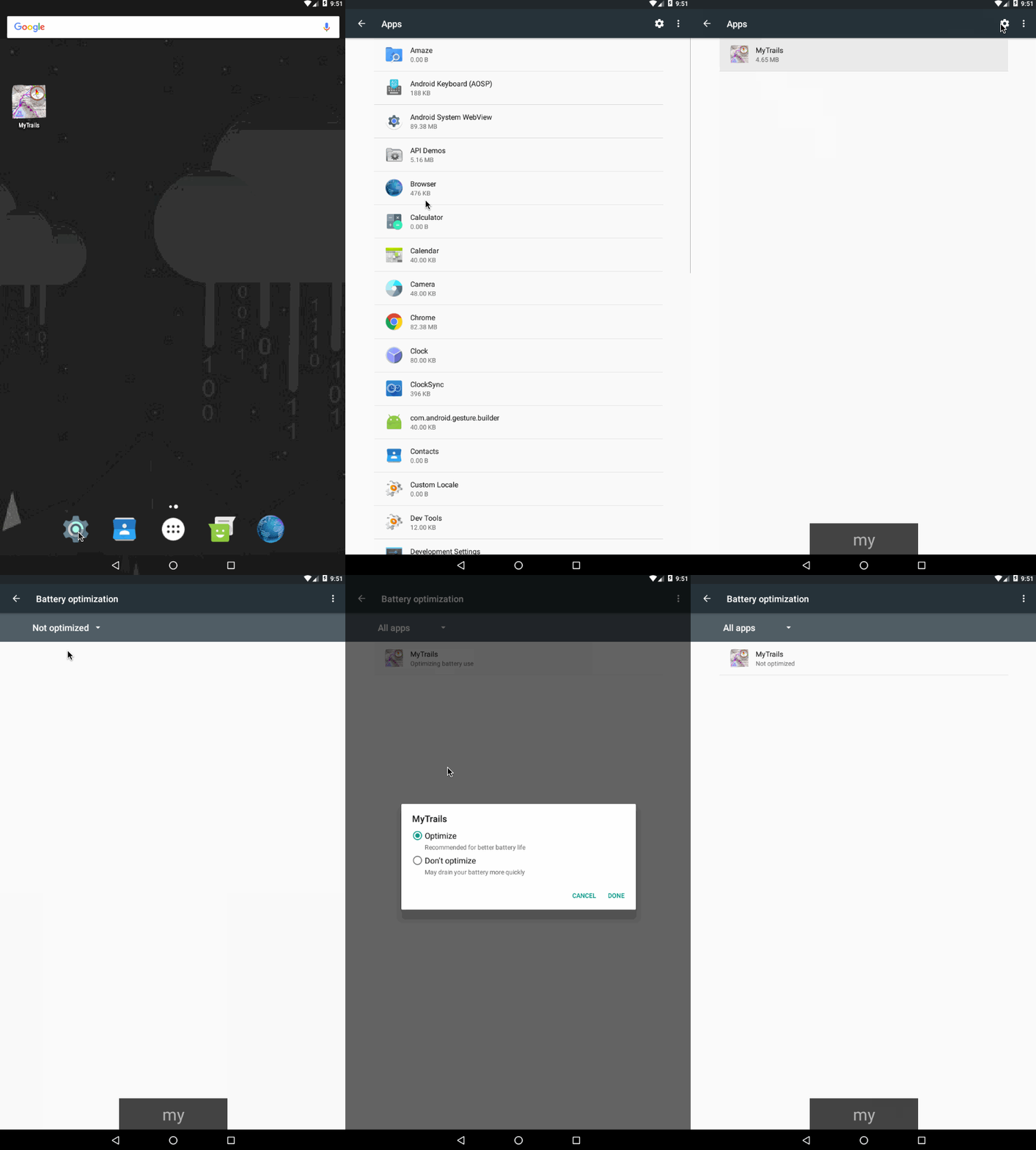
In order to minimize battery impact on the device when recording a track while the screen is off, MyTrails uses the standard method offered by Android where the application is woken up by the OS only when a new track point is ready to be recorded. The top reasons for this are:- Android Marshmallow and later have the ability to stop background apps (to save battery) when the device is not moving. This shouldn't affect MyTrails, except some versions of Android do this incorrectly and also stop apps when you're hiking. In these cases, allowing MyTrails to keep running in the background may help: Android Settings > Apps > gear icon (Configure apps) > Battery optimization > All apps > MyTrails > Don't optimize. Because this is a bit convoluted, I made short animation below.
- Similarly, some customized Android versions such as Samsung's include an Energy Saver feature that disables background GPS. Please check that it is disabled (it sometimes becomes enabled after a system update).
- DontKillMyApp.com lists detailed steps to fix this for the various device manufacturers. Please check this first if you have this problem.
- More info compiled by another GPS tracker app, Strava.
- On some phones, Android may occasionally lose track of this, and forget to wake MyTrails up. This would result on a track where no recording takes place during some stretches where the screen was off. Because this is a platform bug and so far has been reported only once, I do not intend to add a potentially harmful work-around to MyTrails. You can implement the work-around on your phone by downloading Wake Lock from the Play Store and using it to keep a PARTIAL_WAKE_LOCK when running MyTrails.
- Some phones may incorrectly stop recording the track when the Temporal resolution preference in MyTrails is set to something other than 1s.
- System optimizers such as Juice Defender may also stop the GPS when the screen is turned off. Disabling that dubious optimization restores the recording functionality.
- Some devices disable the GPS when the battery is low.
- Some users have reported that using GPS Test to clear and reload the AGPS data may help restore GPS operation for all apps.
- GPS Locker helps prevent GPS from going to sleep on screen off.
- Huawei phones running their Oreo ROM use extreme battery saving techniques, such that only keeping the screen on allows MyTrails to keep recording. Or maybe this page (in French but with Google Translate) may help.
9. How can I plan a track?
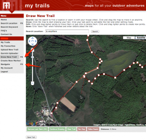
In-application track planning is… planned for MyTrails 2.1. In the meantime, you can use the www.mytrails.com.au (My Trails) web site to plan a track on your computer, and import it into MyTrails. Note that the web site (My Trails) is developed and administered separately from the application (MyTrails, no space) and this web site.- If you don't already have an account on the My Trails web site, create one
- Log in to the My Trails site
- In the menu, select either Draw new trail (for freehand trail definitions, with the option to also snap to roads) or Navigate (to always snap the trail to what Google considers to be navigable)
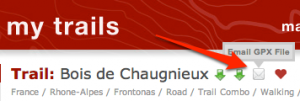
- Create your trail and save it (on the Navigate page, you have the option of sending the trail via email directly to your device so you can open it straight into MyTrails)
- If you saved the trail rather than send it via email
- run MyTrails
- in Preferences > Accounts > My Trails, log in to your My Trails account
- open the Track Manager, then tap the Download button and select My Trails as the source
- the search function looks for tracks around a certain location (current GPS location, current map location or a waypoint): you may have to shift the map to the approximate location of the track first
- If you sent the trail via email, just open your email client on your device and open the attachment. MyTrails should be one of the applications that offers to open the document.
10. Hidden options
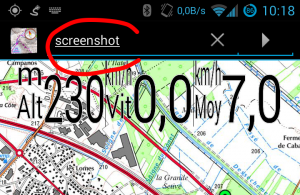
MyTrails uses a trick for some hidden options that are not useful for most users, but which we may ask you to use when tracking down an issue. To use these options, you need to run MyTrails, then select menu > Look for > address or location (on tablets, you can use the search field at the top of the screen) and enter the hidden option name exactly as indicated, all in lower-case and without extra spaces, then run the search. Most options will confirm the action with a toast notification.toggle fake tracker: uses a simulated GPS tracker rather than the actual GPSjump fake tracker: makes the simulated GPS tracker jump (track break)override bad mag sensor: uses relaxed checking for the magnetic sensor (some phones ship with a sensor that inaccurately reports its parameters, causing MyTrails to disregard it, this lets MyTrails use it anyway)toggle no gps warning: MyTrails no longer warns when the GPS is switched offtoggle tracker debug: turns on very verbose debug log for the trackertoggle offline fallback: allows offline maps to use other offline maps as fallback (disabled by default because this makes it possible to create circular references)reset offline: causes MyTrails to look for offline maps, wiping its cachesreset no ask: resets the behavior of all those "and don't ask again" dialogsdump all state: creates an email with all of MyTrails' internal data, to send us so we can diagnose certain issuesbenchmark: a basic benchmark of the map moving around and zooming; run it a few times in a row to make sure the caches are all setset nad27 LOC, where LOC is a lower-case NAD27 location, such ascanada, orwestern_us: sets the datum for UTM coordinates; to get back to using WGS84, useset nad27 nonescreenshot: saves a screenshot (attempts to use 2048x2048 if there is enough memory, and goes down from there)toggle logging system: alternates between standard Android logging, MyTrails logging and both; you can use that when reporting issues and Android logs are not informative (some devices have logging turned off)toggle alternate distance: alternates between the standard Android way of computing distances and a work-around for phones affected by a rare Android bug. As of MyTrails 1.4.6, this has been promoted to an official preference (in Visual).toggle random track color: by default MyTrails assigns a random color to new tracks (because the GPX format doesn't specify a track color, if you load a GPX that was not created by MyTrails, it does not include a color); use this if you want all your tracks the same color.toggle bigger mgm: create offline files with more tiles per file (1024 rather than 64) to better support huge number of tiles even on FAT filesystems (only useful to download entire countries at high zoom)toggle volume zoom: if you don't want MyTrails to capture your volume buttons, use this option.export global waypoints: save your global waypoints to a GPX file (in/sdcard/MyTrails/global_waypoints.gpx) as a backup, which you can later import as a normal GPX (waypoints imported in this manner will not be global). MyTrails 2.0.3b4 and later.toggle track filename display: in the Track manager track list, display the filename for each track rather than the name of the track as defined in the GPX (be aware that GPX files can contain multiple tracks, with different names). MyTrails 2.0.3 and later.toggle check gps readings: allows MyTrails to record GPS points that are obviously not correct for hikers and bikers (by default, MyTrails rejects points with a speed greater than 200km/h).toggle reverse volume zoom: reverse the zoom direction when using the volume buttons.toggle reverse compass: fix the the rotation of the compass, when it seems reversed compared to the actual movement of the phone. Please remember to calibrate the compass before resorting to this.set compass low pass [n]: filter the compass movement (15 is good value)set kalman filter [n]: filter the GPS track (n: approximate nominal speed in m/s, for example 1 for walking, 8 for cycling)toggle cert check: allow MyTrails to ignore failed certificate verification, which may happen on some versions of Android (including Blackberry)toggle proximity wake screen: you can disable MyTrails turning the screen on for proximity notificationstoggle track mode: switch MyTrails' track rendering between smooth triangles (the default), raw triangles and lines (a useful fallback for some display issues)
11. How can I create offline maps from GeoPDF sources?
John Thorn, the developer of mapc2mapc has documented the process.- US Topo maps can be downloaded free (but not hassle-free!)
Canada(no longer available)Australia(no longer available)
12. I deleted a premium map from my phone, how do I get the credits back?
Most premium maps sold via MyTrails are priced according to how much of the map you wish to store on your device. Within that limit, you can download the parts of the map you wish, and when you no longer need a given area, you can delete it and download a different area.
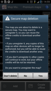
Because MyTrails allows you to use the map on different devices, just deleting the map on one device is not enough, the map needs to be unregistered on the server.
When you try to delete a an offline map you have created from a premium map, MyTrails asks whether you want to just delete the map locally (presumably it can still be used on another device) or also unregister it.
You only get the download credits back if you unregister the map. Even then, you may not get back the exact amount of credits corresponding to the area of the offline map you unregister: MyTrails keeps track of the area of all your offline maps, and computes the total area, excluding overlaps (the area of the union of your maps), which means that if the map you unregister overlaps another map, the overlapping area will not be refunded.
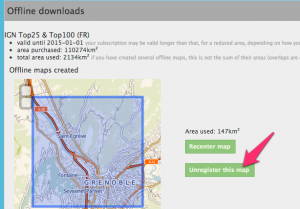
What happens if you make a mistake and omit to unregister it? You need to use our server to unregister it.
- if you do not yet have a FrogSparks account, create one from your device: MyTrails > Preferences > Accounts > FrogSparks > Register, which will associate the maps you have purchased from your device with your account.
- from your device or a computer, go to our self-administration server.
- once you've logged in, you'll see the list of offline maps you have created, and you can unregister the map.
13. My GPS stopped working
This article has been superseded by this new and expanded version. GPS signal is tricky: it's affected by the quality of the phone (the Samsung Galaxy S had notoriously bad GPS reception) and by the environment it's in (indoors, urban canyons or dense forest reduce the quality of the GPS signal). However, all other parameters being equal, if your GPS suddenly seems much worse (the GPS arrow no longer appears even if you're moving faster than 5km/h, MyTrails no longer reports the speed, or the GPS signal quality meter remains red), you may need to reset your GPS. MyTrails doesn't do this for you, but you can install the GPS Test app, go into its settings and tap the Clear AGPS, then Update AGPS buttons. One some devices, setting the Temporal resolution to a value greater than 1s (in MyTrails > Preferences > Behavior) causes the device to stop updating the GPS. This is a bug on your device, and you can work around it by setting the temporal resolution back to its default of 1s. Some devices disable the GPS when the battery is low. Some Kyocera phones for example, disable it below 20% battery, without any visible indications. This may be configurable in the phone's battery saving settings.14. What's a FrogSparks account?
First, what a FrogSparks account is not:- it's not mandatory, even if you're purchasing map subscriptions: you can use map subscriptions on one device, without an account
- it doesn't need to match your Play Store email address
- it is not an account on this web site
- allow you to use your map subscriptions on multiple devices
- make it easier to keep your device connected to your subscriptions if you upgrade your Android version or reset the device
- give you access to the web administration page where you can see a summary of your map subscriptions and the offline maps you have downloaded
FrogSparks accounts remain available if you'd rather not use your Google account everywhere, and can be created from within MyTrails only: MyTrails > Preferences > Accounts > Google (or FrogSparks) and tap on FrogSparks at the bottom of the screen.
15. Can I only subscribe to (not own) premium maps?
MyTrails lets you freely define the locations you download offline, so you don't have to select a particular map number or administrative division when you purchase a map. Also, when you no longer need to have a given map offline, you can remove it and download another map without any additional cost (like a map lending library), so you don't have to pay for a very big subscription, only what you need to have access to simultaneously. This flexibility does mean that we can't offer perpetual licenses (similar to owning, but in the digital world actual ownership is getting scarce).16. Can I extend the size (rather than the duration) of an offline subscription to a premium map?
You can extend the duration and/or extend the volume by purchasing another subscription within MyTrails.
When you purchase another subscription, if it is the same "size" as a current subscription, it by default extends the duration, but you can select the option to add to the current subscription area instead.
Purchasing a subscription of a different size always adds to the area rather than extend the time.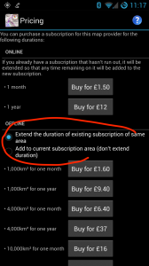
17. How do I join the beta?
The new Play Store rules prohibit MyTrails from self-updating, so while it can check for updates (including optionally beta versions) on startup, it can no longer download and install the update, but must instead wait for the Play Store to perform the update. Google mandates the following process for participating in a beta program:- activate the beta program
- wait for the Play Store to find the update (if there is a beta version more recent than the current release), or go to MyTrails's page on the Play Store to force the update
Getting back to the release track
If you need to go back to a stable version after installing a beta and are not willing to wait for a more recent stable version to be released, do not uninstall MyTrails unless you have made a backup of your current data. If you do, your settings and data will be lost (except tracks saved to GPX).- go to this page and choose Leave the test
- make sure that you have no unsaved recording in MyTrails (a track you've been recording but which has not been saved to a GPX file)
- make a backup:
- if you have rooted your device, you can use Titanium Backup or a similar tool
- if you have not rooted your device or are not sure what "rooted" means, you can use a tool such as MyBackup (you can install it from MyTrails > Preferences > About) or Helium
- once you have a reliable backup, you can uninstall MyTrails, then reinstall it from the Play Store (you should be getting the release version instead of the beta)
- and restore your backup!
18. How do I send the execution log?
When you encounter an issue with MyTrails and ask for assistance (preferably in Google+, but possibly via email), we may ask you to send the execution log for MyTrails. Before attempting to submit a log, please enable error reports in MyTrails > Preferences > About, since all logging is disabled unless you do that. First, make sure you replicate the issue before sending the log, or it will not contain useful information. Also, because Android overwrites information in the log fairly quickly, make sure you send the log rapidly after having replicated the problem. Sending the log is easy, just go into MyTrails > Preferences > About and tap Send usage log. This will submit the log in the background and create an email message so we can correlate the log we receive to the discussion about the issue. Feel free to add information to the email, then send it.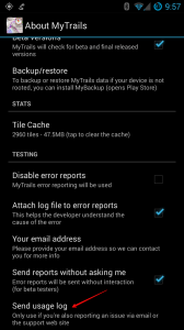 Please take a look at our privacy policy before you send a log, as it does potentially include personal information.
19. MyTrails incorrectly computes distance and speed
MyTrails uses built-in Android methods to compute distances (and speeds). Unfortunately a small number of phones use a version of Android where a critical element of the platform (the Dalvik JIT compiler) suffers from a bug that causes these calculations to be severely incorrect. This issue may also cause tracks to be displayed as thick lines across the screen. In MyTrails 2.0 and later, please try to activate the Fallback distance calculation preference in Visual preferences. In MyTrails 1.3.23 and later, you can work around this problem by using thetoggle alternate distance hidden option.20. Why don't I see my offline maps when I connect my phone to my computer via USB?
This should only happen on CyanogenMod-based ROMs. In order to avoid having the Android Media Manager index all the files MyTrails uses for offline maps (thus wasting space and battery on every startup), MyTrails adds a .noscanandnomtp file to offline maps. This in turn prevents MTP (which your desktop uses to connect to the phone) from seeing these files. If you wish to transfer an offline map from your phone to your desktop (perhaps to share the offline map with a friend), you can:- create a ZIP archive of the offline map (on your phone)
- or temporarily remove or rename the .noscanandnomtp file (using an Android file manager) which is inside the main directory for your offline map, then cause Android to re-index the directory, perhaps by rebooting the phone and waiting a few minutes
21. MyTrails Pro available as an in-app purchase
When I started developing MyTrails, in-app purchases (IAP) were not available on the Play Store, so like all apps from that generation, a tiny app (MyTrails Pro License) served to indicate to the main app that the user had purchased the Pro version. It worked, for the most part, but some users didn't know that they could just download the Pro license again for free when they switched to a new device. So now MyTrails is available as an IAP. Buying it is slightly easier and the minor support burden should be a thing of the past. I also wanted for users who have both a Google device and a Kindle to not have to purchase the Pro version twice just because of the platform divide, so the license information is stored on my server, and it is attached to your FrogSparks account.On Google devices, the FrogSparks account is superseded by using your Google account; on Amazon devices the FrogSparks account remains. If you already have a FrogSparks account (or you also use a Kindle), both accounts can be attached by first connecting to your FrogSparks account, then your Google account, from your Google device.
All this happens in MyTrails > Preferences > Accounts > FrogSparks.
If you already have purchased the Pro license, MyTrails will first prompt you to create or connect to your account, and will transfer the license to the server, after which you will be prompted to uninstall the Pro License (but you don't have to). The Pro License application will remain available on Google Play for the time being, but should no longer be used. tl;dr: If you want MyTrails Pro, from now on the IAP is the way to go, MyTrails will guide you.22. Migration issues between FrogSparks and Google login
If you're a new user, you should always use a Google login on the web site and on your devices (as long as you have configured a Google account on the device, which you have done if you use the Play Store or Gmail): it's easier, one less password to remember, and you should not encounter any problem. If you had already created a FrogSparks account, you should also migrate to using a Google account everywhere. In most cases, simply logging in to your Google account from MyTrails on a device that is also connected to your FrogSparks account should automatically merge your Google account to your FrogSparks account. There is one possibility for failure: if your Google account's email address is not the same as the email address you used for your FrogSparks account and you connect to your Google account from a device not already connected to your FrogSparks account, or from the web site, then both account will remain separate and you will not be able to merge them. You should contact us so we can delete your Google account from our databases so you can then merge the account properly as described above. You may choose to use only a FrogSparks account everywhere (if you don't have a Google account for example). Or once you have an account that works both as a Google account and a FrogSparks account, you can use the FrogSparks account where the Google login is not available (for example on Kindles).23. I changed or reset my phone, how can I get my purchases back?
Background
MyTrails tries hard to keep track of your map subscriptions or Pro status even when it is uninstalled or reset, but sometimes it fails. By default, your purchases are tied to your device through a unique random identifier that MyTrails creates (referred to as the UUID). In some circumstances (device reset, ROM update, etc.), this UUID may be regenerated, which breaks the connection between your device and subscriptions. For this reason, we recommend to also connect MyTrails to your Google account (in MyTrails > Preferences > Accounts > Google), or create a FrogSparks account (if you prefer not to use your Google account everywhere), so that MyTrails may have a more permanent way of tying your purchases to you.Solution
So, provided you did associate MyTrails to your Google or FrogSparks account before you changed or reset your phone, all you need to do to restore your purchases is to connect to your account again (MyTrails > Preferences > Accounts > Google) or in MyTrails' navigation menu. For paid offline maps, once you have restored your account connection, you can copy the map data from the old device to the new (it's usually stored in/sdcard/MyTrails/offline), or you can download it again; because MyTrails subscriptions are based on the area of the union of your downloads, if you download the same areas, you will not have to pay extra (and you can use maps.frogsparks.com to de-authorize maps that you had downloaded to the old device).
If this fails, please contact support@frogsparks.com and provide the email address associated with your Google (or FrogSparks) account, as well as the Google Wallet purchase number for the purchases (you can find it on the email receipts from Google, or on wallet.google.com).24. How can I use my external SD card for offline maps?
One of the new "features" of Android 4.4 (KitKat) is that applications can no longer use the external SD card as a generic storage volume and read/write everywhere. There are valid security reasons for the change, but the way Google has done this breaks many apps and doesn't provide a clear way to do things right for application developers.
In the case of MyTrails, it means that if you want to store your offline maps on your external SD card, you'll have to jump through a few hoops:
- If your device is rooted, you can use a free app like SDFix to revert to a fully-writable SD card
- If your device is not rooted, there is only one folder that MyTrails can write to on the external SD card:
/storage/sdcard1/Android/data/com.frogsparks.mytrails(this path may be slightly different if you're using the preview version of MyTrails, or your device mounts the SD card to a different location within/storage; some devices use/storage/extSdCard/)
Please note the following caveats (if your device is not rooted):
- you can not share the same offline maps between the official and preview versions of MyTrails
- if you uninstall MyTrails, your offline maps will be deleted (this is by design, part of the reason Google make this change in KitKat), unless you use a privileged file manager (one that comes as part of your device's default software) to move them beforehand
On recent versions of Android, even the internal storage may no longer be accessible to MyTrails. One location that should always be available is /sdcard/Android/data/com.frogsparks.mytrails. This is the offline location you should use if all else fails. Warning: that location is deleted by Android when you uninstall MyTrails!
Alternately, you can use the standard Android file picker with MyTrails, which makes it possible to load and save GPX files from anywhere. Enable it by turning off Use internal file picker in MyTrails > Preferences > Other.
25. How can I temporarily hide the waypoints to see the map
It's easy: just start a pinch gesture, as if you wanted to zoom in, and keep your fingers on the screen. The waypoints disappears as soon as you start to zoom, and will come back when you lift your fingers.26. Compass calibration
MyTrails can use your phone's built-in magnetometer and accelerometer to simulate a compass. However, unlike a physical compass, phones need to be periodically calibrated to provide an accurate reading of the magnetic north bearing. There are two methods (both need MyTrails to be running with the screen on – MyTrails disables the compass when the screen is off):- turn the phone around each of its axes in succession; this is the most accurate method, but it takes a bit longer and there's more chance of dropping it
- use a figure-8 movement; this is quicker but doesn't always provide enough data for full calibration
toggle reverse compass hidden option.
In addition to the compass, MyTrails can use the GPS-derived heading, with the following caveats: it's only active above 1m/s (too imprecise at slower speeds), and the GPS heading indicates the direction of your travel, not the direction the phone's screen is pointing.
Another method, described by Google.27. I made a purchase but MyTrails failed to activate it
In some very rare cases, MyTrails may have trouble activating a purchase you made via in-app purchase, so Google (or PayPal) will have charged your account but MyTrails doesn't register that fact. MyTrails usually warns you of the fact and suggests corrective measures; even if it doesn't, the first things to try are:- make sure MyTrails is connected to your Google or FrogSparks account (MyTrails > Preferences > Accounts > Google or FrogSparks) or in MyTrails' navigation menu
- if you made your purchase from within MyTrails
- trigger a new attempt to register your purchase by going into MyTrails > Preferences > About > Retry purchase (in MyTrails 2.0.3 or later – in earlier versions go to the same screen you initially tried the purchase)
- for purchases from the web site
- the account you used to connect to the web site (and the email address on which you received the confirmation email) matches the account to which MyTrails is connected (displayed at the bottom of the navigation menu)
- if this doesn't work, please contact support@frogsparks.com, providing the following information (clicking the link provides a pre-formatted email for this):
- the email address of the account MyTrails is connected to
- your Google Wallet (from Google's confirmation email or wallet.google.com) or PayPal (from their email or www.paypal.com) purchase number
28. MyTrails is always looking for a GPS signal – AKA how can I stop MyTrails?
MyTrails can record your track whether it's visible or running in the background. Even if you're not recording a track, MyTrails may use the GPS if you have the proximity notifications option turned on. When you want to stop using MyTrails, you should quit it like any other application (including Google Maps), by using the back key or button. When you do this, MyTrails asks you whether you want to keep recording the track in the background. Answer 'no' to stop MyTrails entirely. [caption id="attachment_2675" align="aligncenter" width="300"] Back button[/caption]
[caption id="attachment_2676" align="aligncenter" width="300"]
 Back key[/caption]
Note that MyTrails doesn't ask about quitting if you have already paused track recording. You can also use the Pause button in the recording notification to stop recording.
[caption id="attachment_2677" align="aligncenter" width="300"]
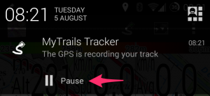 Recording notification[/caption]
If you find this confusing, you can enable a Quit option to the navigation menu in MyTrails > Preferences > Other.
If you have used MyTrails beta, it may be set to use "enhanced GPS", which introduces an issue. Please check in MyTrails > Preferences > Sensors that enhanced location is turned off.
Recording notification[/caption]
If you find this confusing, you can enable a Quit option to the navigation menu in MyTrails > Preferences > Other.
If you have used MyTrails beta, it may be set to use "enhanced GPS", which introduces an issue. Please check in MyTrails > Preferences > Sensors that enhanced location is turned off.29. How can I move already downloaded offline maps to my external SD card
So you've downloaded a bunch of maps offline, and MyTrails placed them on your phone's internal storage? MyTrails doesn't attempt to help do this, because moving large amounts of data around is difficult to do in a compatible and safe way. So please follow this guide:- in MyTrails > Preferences > Other (storage), set the New offline maps location to your external SD card (you can use the SD card icon if you see one, or navigate to the external SD card if not)
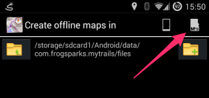
- use an Android file manager such as ES Explorer to move the contents of
/sdcard/MyTrails/Offlineto the location you selected above if this is not possible (Android 4.4 and later, unless rooted), transferring the files using a computer is required - in MyTrails > Maps, tap on each of the offline maps you created and adjust its location
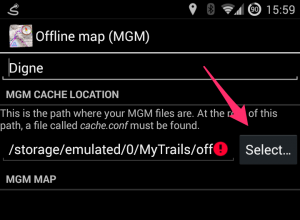
If this does not succeed, please use the reset offline hidden option.
30. New recording UI
MyTrails 2.0.9 introduces a new recording UI, which should make it easier for new users to grasp what the application is doing. The original recording UI is still available and will continue to be supported for users who prefer a greater degree of control.How to select
You can select the type of recording UI in MyTrails > Preferences > Recording, Extended recording UI (uncheck for the new UI).How does the new recording system work?
The new system consists of two buttons: Record/Pause and Stop. [caption id="attachment_2813" align="aligncenter" width="239"] Currently recording[/caption]
The icon that is lit corresponds to the current recording state. Tap a button to switch to that state. For example, to pause the recording (without saving and closing the track), tap Record/Pause.
Tap the Stop button when you are done with your recording: MyTrails asks you to save the track (providing a name, etc.), and possibly upload the track to a community. The recording is then cleared, so MyTrails is ready for another recording, which you can do immediately by hitting the Record button.
You can also find the recording controls in the navigation menu, which is available on all main screens (stats, graphs, tracks, maps, etc.), not just the map view.
Streamlining the recording experience
With this new mode, MyTrails tries to make it very quick and easy to record your tracks:- when you launch MyTrails, recording starts right away (unless MyTrails was exited in the paused state)
- when you get back to your starting point, MyTrails reminds you to save the recording with an unobtrusive notification (you can dismiss it by swiping it away; you can also disable this feature)
- when you stop the recording and save the track, you can leave MyTrails any way you like:
- just sending MyTrails to the background (using the Home button) stops using the GPS
- actually quitting (using the Back button) is still better: when you next start it, MyTrails will know to start recording a new track
31. Cumulated climb or descent
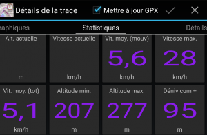 In order to calculate the cumulated altitude differential, MyTrails must identify parts of the altitude curve where the track switches from uphill to downhill or vice versa. Because altitude measurements are not exact (especially from the GPS), MyTrails uses a filter to attempt to differentiate measurement errors from actual changes in the track.
Different applications use different filters, which may yield very different altitude differentials.
You will get better results when using altimeter-derived altitudes, or after applying altitude normalization (when saving the track, or in the Track Manager).
In MyTrails 2.0.11 and later, you can additionally use two options in Preferences > Sensors: Altitude stabilization (which performs some filtering on GPS altitude data to reduce the noise) and Cumulative climb filter, which you can set higher to avoid MyTrails overestimating cumulative climb when the GPS data is very noisy.
In order to calculate the cumulated altitude differential, MyTrails must identify parts of the altitude curve where the track switches from uphill to downhill or vice versa. Because altitude measurements are not exact (especially from the GPS), MyTrails uses a filter to attempt to differentiate measurement errors from actual changes in the track.
Different applications use different filters, which may yield very different altitude differentials.
You will get better results when using altimeter-derived altitudes, or after applying altitude normalization (when saving the track, or in the Track Manager).
In MyTrails 2.0.11 and later, you can additionally use two options in Preferences > Sensors: Altitude stabilization (which performs some filtering on GPS altitude data to reduce the noise) and Cumulative climb filter, which you can set higher to avoid MyTrails overestimating cumulative climb when the GPS data is very noisy.32. Connecting MyTrails (or reconnecting)
To connect MyTrails to your Google account so you can share subscriptions between devices, just open the side navigation menu and tap the Connect button. [caption id="attachment_2881" align="aligncenter" width="169"]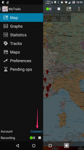 Tap the icon in the top-left of the screen to open this menu[/caption]
In the screen that opens, tap Connect again, choose one of your Google accounts (always the same!) if you have more than one and go through the authorization.
[caption id="attachment_2876" align="aligncenter" width="169"]
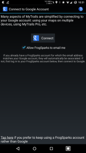 Tap connect, then accept the authorization prompts[/caption]
In the side navigation menu, the Connect button will be replaced with the email address of your account.
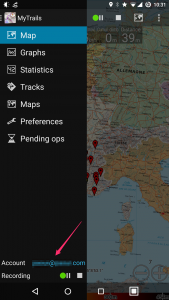
Reconnecting
Sometimes, MyTrails needs to refresh the association with your Google account. In that case, open the side navigation menu, tap the email address, and in the next screen, Disconnect, then Connect again. [caption id="attachment_2880" align="aligncenter" width="169"]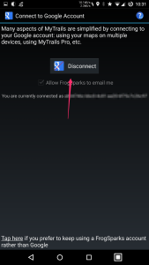 Tap Disconnect, then Connect again[/caption]
33. Combining maps
In order to make it easier to manage offline maps, I usually recommend creating separate offline maps for separate geographical areas. However, this makes it necessary to switch maps when looking at different parts of the map. Unless you chain maps together using the fallback map feature. [caption id="attachment_2960" align="aligncenter" width="300"] Picking a fallback map[/caption]
Most maps, and particularly offline maps, support setting a fallback map. To do so, tap the name of the map in the Map manager, and then the
 Select… button in the Fallback map section. You can then pick the fallback map, which will be used where the main map does not provide a tile.
Using this system, you can chain maps together:
- set the fallback map for map A to map B
- set the fallback map for map B to map C
- etc.
- in the main MyTrails view, select map A, and MyTrails will automatically display map B or C in areas not covered by map A.
Let MyTrails download missing tiles option.
[caption id="attachment_2963" align="aligncenter" width="300"]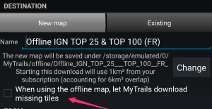 Create offline map with fallback[/caption]
34. How can I transfer GPX tracks to my computer?
MyTrails store the GPX files for tracks you have recorded in/sdcard/MyTrails/gpx (you can change this in MyTrails > Preferences > Other).
Here are a few methods you can use to transfer track files:
- the most basic method for transferring files is to connect your device to the computer via USB (make sure to set the USB transfer mode to MTP, and on Mac use Google's Android File Transfer to copy the files over). More info here.
- another method is to use a file manager on Android to copy the files to a physical SD card (if you have one and can plug it into your device) and then read the SD card on the computer
- MyTrails Pro has built-in support for saving tracks to Dropbox (or a track-sharing community such as GPSies); if you also use Dropbox on your computer, the file will magically appear there
- finally, in MyTrails' Track Manager, you can long-tap a track and use the Share menu to send the file via email or another app that is capable of sharing files
35. How to dissociate my device from the FrogSparks account
When MyTrails tries to connect to an account, the server checks whether the device MyTrails is running on has previously been associated with a different account. This is to try and make it less likely users will create multiple accounts, and to reduce the support burden of having to reconcile accounts when they do. When it happens to you, MyTrails will display an error message, and in the background, the server will send an email to the address associated with the account previously used on the device.- If you do receive that email, please log in to maps.frogsparks.com, using the account indicated in the email, and remove the device from the account.
- If you have current subscriptions associated with the account, please email support@frogsparks.com with the email addresses of the account that needs to be closed and the account you want the purchases transferred to.
- If you do not receive the email, either the address is no longer current or it belongs to someone else. In that case, please send me a log from the device, and in the email indicate the email address of the account you're trying to connect to.
36. Moving to another device
Here's a checklist of things you should do to move all your data when you change devices:- on your old device, make sure MyTrails is connected to your account, so your purchases, if any, will be available on your new device
- make a backup of MyTrails' state on your old device
- if you have rooted your device, you can use Titanium Backup or a similar tool
- if you have not rooted your device or are not sure what “rooted” means, you can use a tool such as MyBackup (you can install it from MyTrails > Preferences > About) or Helium
- if you can't make a backup, at least export your waypoints from MyTrails into a GPX, by using the
export global waypointshidden option
- unless you keep all your recorded tracks in Dropbox, make a copy of your recorded tracks on your computer
- if you have offline maps, you can copy them to your computer as well
- on your new device, install MyTrails (you don't need to install the MyTrails Pro License application unless you haven't connected MyTrails to your account in step 1)
- if you made a backup in step 2, restore it on the new device
- make sure MyTrails on the new device is connected to your account
- check that your recorded tracks are still available (if not, copy them from your computer to the new device, and load them into MyTrails)
- make sure your offline maps are still available (if not, first check the location for offline maps in MyTrails > Preferences > Other, then copy them from your computer to that location and restart MyTrails)
- check that your global waypoints are still available (if not, load the exported
global_waypoints.gpx; unfortunately the waypoints will no longer be global, but will remain associated with that track, which you should leave checked)
37. Blackberry devices can't connect to account
MyTrails mostly works well on Blackberry 10 devices, but because Blackberry doesn't include the same sets of security certificates that other modern OSes do, it's not able to connect to my server for things like creating an account or purchasing maps. Two solutions:- upgrade to the latest Blackberry 10 version (10.3.3)
- install multiCERT and use it to upgrade the certificate database
38. Bug on Android 7 (Nougat)
MyTrails 2.0 is not fully compatible with Android Nougat (7.0), and in the Track Manager I have disabled long-tapping to select a track, so the ability to perform actions on tracks is not longer available. MyTrails 2.1, a major rewrite of important parts of the app to make it compatible with the latest Android versions, is now available in the beta track. To get the beta release, please opt-in here.39. OpenCycleMap API KEY REQUIRED
OpenCycleMap is operated by ThunderForest, a paid service. They overlay the message "API KEY REQUIRED" on their maps to encourage users to register with them. You can create a free account and update the map definition in MyTrails > Maps > tap on the OpenCycleMap entry and edit the map URL, adding?apikey=123abc at the end of the existing URL, where 123abc should be replaced with your real API Key.
The first part of the URL may also need to be changed from a.tile.opencyclemap.org
to a.tile.thunderforest.com.
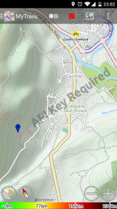
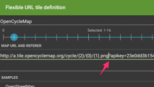
40. MyTrails records zigzag around my track
This means your GPS signal is noisy, which may be:- because your GPS module is not very sensitive or misconfigured
- because of the terrain (in thick woods or canyons)
- because it's stored at the bottom of a backpack or pocket
- because of jamming (intentional or power lines)
set kalman filter n hidden option, where n is the approximate nominal speed in m/s, for example 1 for walking, 8 for cycling.41. FrogSparks licensing server blocked by Russian government
According to this site, maps.frogsparks.com is among many sites being blocked by the Russian government (technically, the IP address the host resolves to is part of a large block "B-class" of IPs blocked wholesale by Russia – the block is not targeted at MyTrails specifically). This means that for users in Russia, MyTrails Pro can no longer verify its licensing status, and will revert to Free mode even if you have paid. If you are affected by this, you can use a VPN to allow MyTrails to get around the block. The licensing status must be verified at least once every two months. MyTrails 2.1.4b2 contains a workaround for this.42. Why do directions, search and nearby POI search no longer work?
Google some time ago switched all maps-related APIs from free to paid, which requires changes in apps that use those APIs. Because MyTrails can aggregate several similar services, I didn't immediately realize that some functionality MyTrails relies on was no longer available.
I will be releasing an update that restores directions, POI search and location search functionality. For Pro users, I will test whether MyTrails can keep using the paid Google APIs, but for free users, MyTrails will likely have to switch to free services, such as OSM, and I may have to restrict directions.
You can restore some of the search functionality in MyTrails 2.1.4 by enabling the OpenStreetMap search provider in MyTrails > Preferences > Other.
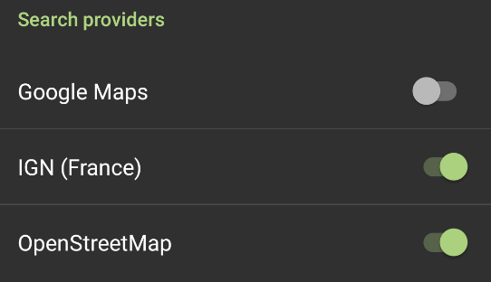
In the latest 2.1.6 beta, Google search, directions and altitude are fixed.
43. MyTrails displays extra lines on my recorded tracks
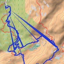
On some devices, MyTrails draws recorded tracks with lines leading back to the start of the recording. This is only a display issue, and the lines change when you zoom in or out.
For the moment, to fix this, use the toggle track mode hidden option to select the Lines mode.
If this doesn't fix the problem, you can use the same hidden option to get back to Smooth triangles, and check that the problem is not with the recording itself.
44. Offline maps and GPX save location with Android 11
As Google continues to make it harder for applications to share data, you may have to move your offline maps and GPX save location to a MyTrails-specific folder rather than the traditional /sdcard/MyTrails.
Several users have reported that using a folder like android/media/com.frogsparks.mytrails (inside the main device storage, presumably also on a removable storage) works.
If you're not using offline maps (only GPX saved tracks), you can probably stick with your usual save location, but you need to switch to the standard Android file picker (disable Use internal file picker in MyTrails > Preferences > Other).
For more general info, see this older post.
45. Cartes IGN sur Android 7, 8 et 9
Manifestement, depuis le 20 mars, IGN a mis à jour un certificat sur leurs serveurs, et il n'est pas compatible avec les versions d'Android inférieures à 10, ce qui fait que les cartes IGN ne se chargent plus dans MyTrails.
Il y a une méthode de contournement (à part mettre à jour la version Android lorsque c'est possible) : installer ce certificat explicitement :
- télécharger https://www.visugpx.com/divers/certif_ign.cer sur votre téléphone
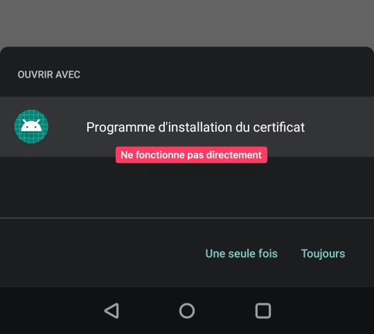
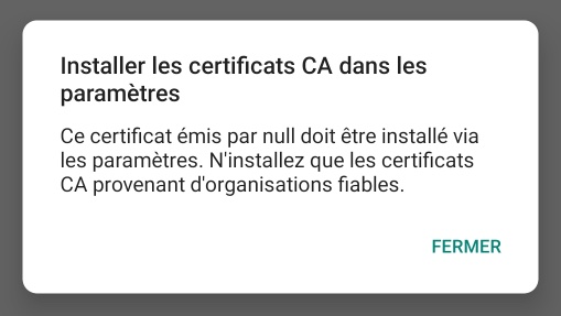
- lors du téléchargement, Android vous proposera peut-être de l'installer directement ; ça ne fonctionne pas, il faut l'installer manuellement depuis les paramètres
- aller dans les paramètres d'Android et rechercher Certificat
- sélectionner Installer Certificat CA
- accepter les mises en garde d'Android
- trouver le certificat là où vous l'avez téléchargé et l'installer
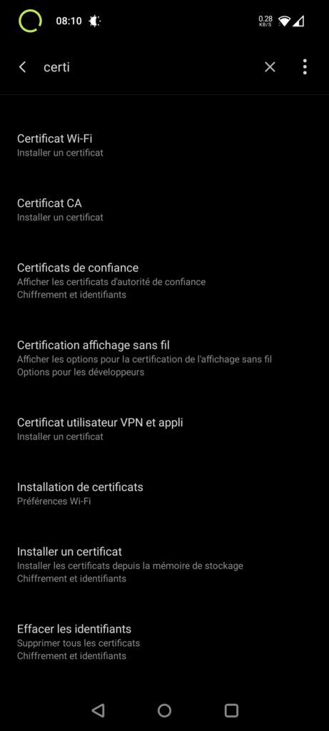
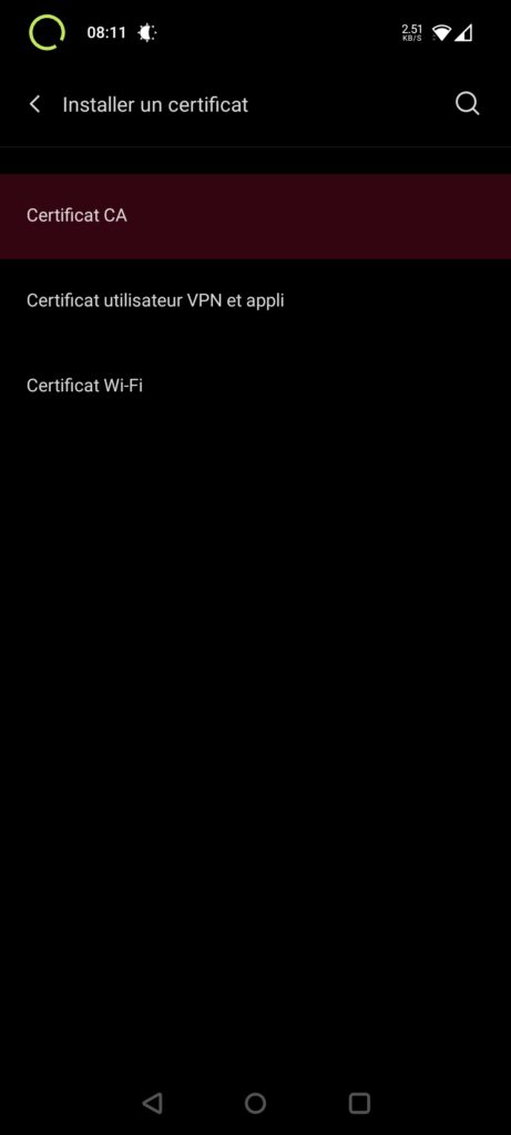
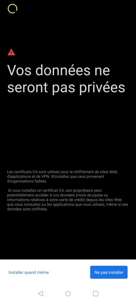
Cette solution provient de https://skitour.fr/forums/362324_2, et elle fonctionne dans une majorité de cas, mais plusieurs cas de problème ont été remontés :
- installation impossible (on peut installer un certificat VPN ou Wifi, mais pas CA)
- il est possible que sur certains téléphones l'installation doive être faite différemment, ou soit bloquée par des paramètres de sécurités
- l'installation fonctionne et permet de consulter les cartes sur le site Géoportail, mais MyTrails n'utilise pas le nouveau certificat, et ne parvient donc pas à charger les cartes
- dans ce cas, seule une mise à jour de MyTrails pourrait résoudre le problème, et ce n'est pas à l'ordre du jour car l'application n'a pas été mise à jour depuis tellement longtemps que ça nécessiterait un long travail pour un très faible nombre d'utilisateurs. Désolé si vous faites partie des utilisateurs affectés.

