Category Archives: Troubleshooting

OpenCycleMap API KEY REQUIRED

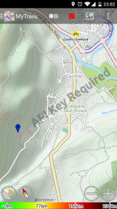
OpenCycleMap is operated by ThunderForest, a paid service. They overlay the message “API KEY REQUIRED” on their maps to encourage users to register with them.

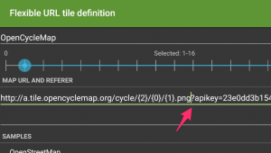
You can create a free account and update the map definition in MyTrails > Maps > tap on the OpenCycleMap entry and edit the map URL, adding ?apikey=123abc at the end of the existing URL, where 123abc should be replaced with your real API Key.

The first part of the URL may also need to be changed from a.tile.opencyclemap.org
to a.tile.thunderforest.com.

Screenshot_2017-04-22-23-02-41

Bug on Android 7 (Nougat)

MyTrails 2.0 is not fully compatible with Android Nougat (7.0), and in the Track Manager I have disabled long-tapping to select a track, so the ability to perform actions on tracks is not longer available.

MyTrails 2.1, a major rewrite of important parts of the app to make it compatible with the latest Android versions, is now available in the beta track. To get the beta release, please opt-in here.

Blackberry devices can’t connect to account

MyTrails mostly works well on Blackberry 10 devices, but because Blackberry doesn’t include the same sets of security certificates that other modern OSes do, it’s not able to connect to my server for things like creating an account or purchasing maps.

Two solutions:

  • upgrade to the latest Blackberry 10 version (10.3.3)
  • install multiCERT and use it to upgrade the certificate database

How do I send the execution log?

When you encounter an issue with MyTrails and ask for assistance (preferably in Google+, but possibly via email), we may ask you to send the execution log for MyTrails.

Before attempting to submit a log, please enable error reports in MyTrails > Preferences > About, since all logging is disabled unless you do that.

First, make sure you replicate the issue before sending the log, or it will not contain useful information. Also, because Android overwrites information in the log fairly quickly, make sure you send the log rapidly after having replicated the problem.

Sending the log is easy, just go into MyTrails Preferences About and tap Send usage log. This will submit the log in the background and create an email message so we can correlate the log we receive to the discussion about the issue. Feel free to add information to the email, then send it.

2013-07-16 09.57.25.png 2013-07-16 16-12-55

Please take a look at our privacy policy before you send a log, as it does potentially include personal information.

Hidden options

MyTrails uses a trick for some hidden options that are not useful for most users, but which we may ask you to use when tracking down an issue.

To use these options, you need to run MyTrails, then select menu > Look for > address or location (on tablets, you can use the search field at the top of the screen) and enter the hidden option name exactly as indicated, all in lower-case and without extra spaces, then run the search. Most options will confirm the action with a toast notification.

  • toggle fake tracker: uses a simulated GPS tracker rather than the actual GPS
  • jump fake tracker: makes the simulated GPS tracker jump (track break)
  • override bad mag sensor: uses relaxed checking for the magnetic sensor (some phones ship with a sensor that inaccurately reports its parameters, causing MyTrails to disregard it, this lets MyTrails use it anyway)
  • toggle no gps warning: MyTrails no longer warns when the GPS is switched off an official option is now available in the preferences
  • toggle tracker debug: turns on very verbose debug log for the tracker
  • toggle offline fallback: allows offline maps to use other offline maps as fallback (disabled by default because this makes it possible to create circular references) circular references are now handled dynamically
  • reset offline: causes MyTrails to look for offline maps, wiping its caches
  • reset no ask: resets the behavior of all those “and don’t ask again” dialogs an official option is now available in the preferences
  • dump all state: creates an email with all of MyTrails’ internal data, to send us so we can diagnose certain issues
  • benchmark: a basic benchmark of the map moving around and zooming; run it a few times in a row to make sure the caches are all set
  • set nad27 LOC, where LOC is a lower-case NAD27 location, such as canada, or western_us: sets the datum for UTM coordinates; to get back to using WGS84, use set nad27 none
  • screenshot: saves a screenshot (attempts to use 2048×2048 if there is enough memory, and goes down from there)
  • toggle logging system: alternates between standard Android logging, MyTrails logging and both; you can use that when reporting issues and Android logs are not informative (some devices have logging turned off)
  • toggle alternate distance: alternates between the standard Android way of computing distances and a work-around for phones affected by a rare Android bug. As of MyTrails 1.4.6, this has been promoted to an official preference (in Visual).
  • toggle random track color: by default MyTrails assigns a random color to new tracks (because the GPX format doesn’t specify a track color, if you load a GPX that was not created by MyTrails, it does not include a color); use this if you want all your tracks the same color.
  • toggle bigger mgm: create offline files with more tiles per file (1024 rather than 64) to better support huge number of tiles even on FAT filesystems (only useful to download entire countries at high zoom)
  • toggle volume zoom: if you don’t want MyTrails to capture your volume buttons, use this option.
  • export global waypoints: save your global waypoints to a GPX file (in /sdcard/MyTrails/global_waypoints.gpx) as a backup, which you can later import as a normal GPX (waypoints imported in this manner will not be global). MyTrails 2.0.3b4 and later.
  • toggle track filename display: in the Track manager track list, display the filename for each track rather than the name of the track as defined in the GPX (be aware that GPX files can contain multiple tracks, with different names). MyTrails 2.0.3 and later.
  • toggle check gps readings: allows MyTrails to record GPS points that are obviously not correct for hikers and bikers (by default, MyTrails rejects points with a speed greater than 200km/h).
  • toggle reverse volume zoom: reverse the zoom direction when using the volume buttons.
  • toggle reverse compass: fix the the rotation of the compass, when it seems reversed compared to the actual movement of the phone. Please remember to calibrate the compass before resorting to this.
  • set compass low pass [n]: filter the compass movement (15 is good value)
  • set kalman filter [n]: filter the GPS track (n: approximate nominal speed in m/s, for example 1 for walking, 8 for cycling)
  • toggle cert check: allow MyTrails to ignore failed certificate verification, which may happen on some versions of Android (including Blackberry)
  • toggle proximity wake screen: you can disable MyTrails turning the screen on for proximity notifications
  • toggle track mode: switch MyTrails’ track rendering between smooth triangles (the default), raw triangles and lines (a useful fallback for some display issues)

Enter the hidden option text in the search field