Tag Archives: maps

A few new maps

With the latest beta of MyTrails, add a map configuration by just clicking a specially-formatted link. Here’s a short list of maps to explore:

Visitor maps are composed of geo-referenced park maps (not all parks are represented)

Buy maps directly on our website at a discount!

It’s no secret Google took their cue from Apple when they designed the pricing structure for app purchases (and in-app purchases): like them they keep 30% of any and all sales, with the developer getting the remaining 70%.

This is fair for apps; after all they offer exposure, easy and integrated payment, and the greatest platform there is (hmm, does he mean Apple or Google is the greatest platform, or both?). And since 75% of paid apps on the Play Store are sold for less than $2.50, the fact that Google keeps close to a third of it doesn’t matter much.

For in-app purchases, especially fairly expensive ones, it does matter a bit more! So I’m happy to report that you can now purchase maps at a discount when you get them directly on our site.

We use Google Wallet for payment, and since that’s the same back-end Google uses for the Play Store, if you’ve ever bought an app or made an in-app purchase on Android, your account should be already set up.

Coupled with the upcoming MyTrails integration with Google accounts, this should make buying maps a snap. And about 10% cheaper than IAPs. The prices listed on our topo maps pages remain the IAP prices, and you can click through for the direct price.

At the moment, the prices indicated on our storefront are in Euros, but once you click the Purchase button, Wallet should translate that into Pounds pronto.

New storefront


We’ve also taken the opportunity to redesign the account page to make it less ugly. Please let us know if we missed or broke something!

Using Ordnance Survey maps? MyTrails needs you!

Update: Ordnance Survey maps are no longer available for sale in MyTrails

If you have a current subscription, you can use it until it runs out, but you won’t be able to renew it.

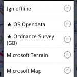
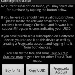
On new installs of MyTrails, OS maps are not defined by default, so if you reinstall MyTrails and you do have a subscription, you can add the map by going into MyTrails > Preferences > Map Manager and tap Add, then select the OS map you have a subscription for. You also need to be logged in to your FrogSparks account for the subscription to be recognized.

Read on for information about why this came about.


Three great pieces of news about Ordnance Survey

Ordnance Survey Licensed Partner

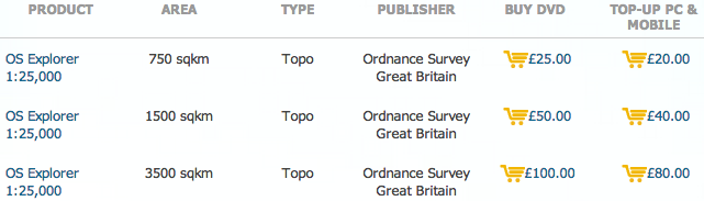
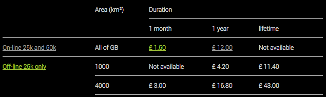
1. Price reduction on OS 25k

Ordnance Survey recently updated their pricing, and they are finally offering degressive pricing for offline maps (and at a much more reasonable price) for their 25k maps.

This is great news, as it makes it possible to keep all of UK 25k mapping offline for about 120£ per year (not that you need to, since with MyTrails you can exchange parts of offline maps you no longer need in exchange for other bits).

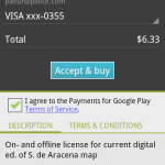
More realistically, it sharply reduces the price of the most popular offline subscription (4000km²) from £38 to £16.80.

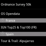
In order to minimize the price as much as possible, I have split 50k maps apart, because the price of the 50k map is no longer negligible next to that of the 25k map. You can subscribe to both to create a hybrid offline in MyTrails.

If you’ve purchased a subscription since October 1st based on the old pricing and would like to take advantage of the new one, please send me the Wallet transaction number so I can cancel your order and you can purchase one of the new subscriptions.

Please note that Offline OS25k maps require MyTrails 1.4.0b3 or later.

2. Lifetime subscriptions are available

Previously, Ordnance Survey required that perpetually-licensed maps be downloadable only once (which I felt to be incompatible with MyTrails’ design philosophy), but now they offer a new lifetime license (in some locations, MyTrails also refers to it as a perpetual license), which does allow unlimited re-downloads, so MyTrails supports that.

It costs a bit over twice the yearly license, but you can use it as long as you like. It’s not quite like owning the map (because you can only use it with MyTrails – again, this is an Ordnance Survey requirement, not mine), but it’s as close as it gets this side of the digital divide.

3. OS has stopped one app that used OS maps without a license

Actually, this is good news for me (or should be, see below) or if you care about using officially-licensed maps…

In October, OS finally prevailed upon another Android app that was offering OS maps without a license (for free) to stop doing so. Since this application has way more users than MyTrails, this resulted in an uptick in the number of OS licenses I sold.

There is still another well-known app out there giving access to free OS maps… and that app is not free. If you look for it, you’ll find it :-).

More seriously, by all accounts these free OS maps are old (they’re still the same maps MyTrails used to offer in 2011, before Ordnance Survey asked me to stop and I switched to licensed maps) and they’re badly compressed and blurry. But people still use them because licensed maps are expensive, and I totally sympathize with that.

… And one not so great

There’s no easy way to say this, so here it is: Ordnance Survey requires a minimum yearly license revenue, and I’m not meeting it. Especially since they lowered their prices (which is great, did I mention that?).

This is where I need your help.

By early January 2014 I will have to stop selling OS maps, unless I can substantially increase my sales. So please talk to your hiker friend, your mtb buddy, the crazy climber dude who keeps threatening to rope you in. Tell them about MyTrails, about how irreplaceable OS maps are, and how you can do more with them when you use MyTrails.

And get them to treat themselves to a map subscription for Christmas.

If I have to cancel my Ordnance Survey license, your maps will not stop working. Online and offline map subscriptions will continue to work for the duration you paid for. You will still be able to exchange parts of your offline maps for new areas. But you will no longer be able to purchase additional OS map coverage to use with MyTrails, and I will no longer be able to update the maps to the latest OS data.

I can promise you that despite the fact that OS is more interested (legitimately) in the companies that have been selling tiny maps areas for £100 (and still are selling at over twice the price I am, after the price reductions), I will continue to work tirelessly to make MyTrails a great app for you.

Brand B pricing

Brand B pricing

And if I should have to cancel my OS contract, any OS map purchased between December 1st 2013 and January 15th 2014 will be reimbursed in full upon request.

So please head to our new storefront and help us keep our Ordnance Survey reseller license!

IGN Littoral (France)


Highly-detailed coastal maps of France (mainland and French territories overseas, available only in coastal areas, please check the free trial or inquire with us before purchasing).

Purchase the maps directly through our website rather than as an In-App Purchase (IAP) to save around 20% off the prices below.

The Littoral maps is now available as part of the global IGN on-line maps.

Legend

You can download the legend.

Samples

Littoral zoom 14 Littoral zoom 13
Zoom 14 Zoom 13

IGN Cadastre (France)


Highly-detailed land register maps of France (mainland and French territories overseas, available only where the land register has been digitized, please check the free trial or inquire with us before purchasing).

Purchase the maps directly through our website rather than as an In-App Purchase (IAP) to save around 20% off the prices below.

This map is now available as part of the global IGN on-line and/or off-line maps.

Samples

Zoom 18 Zoom 18 (pixel-doubled)

OS Opendata (Great Britain)

Install MyTrails and start using OS Opendata maps

By John Thorn

A skillful combination of Ordnance Survey Opendata maps with OpenStreetMap. This map is available online and offline for the same affordable price.

Purchase the maps directly through our website rather than as an In-App Purchase (IAP) to save around 20% off the prices below.

Area (km²) Duration
2 months 1 year
On-line and off-line Unlimited £ 1.00 £ 5.00

Samples

Zoom 15 (pixel-doubled) Zoom 14

IGN TOP 25, TOP 100, Cadastre and Satellite (France)

Install MyTrails and start using IGN maps

Highly-detailed topographical maps of France (mainland and French territories overseas) available in 1:25,000 and 1:100,000 (plus less-detailed overview maps).

The TOP 25 maps have all GR paths in highly-visible purple, and many smaller paths. The TOP 100 are very clear and legible overview maps with the main paths. And of course roads, points of interest and altitude references.

Purchase the maps directly through our website rather than as an In-App Purchase (IAP) to save around 20% off the prices below.

Area (km²) Duration
1 month 1 year
On-line only TOP 25, TOP 100, Cadastre, Littoral and Satellite All of France € 4.00 € 16.00
On-line TOP 25, TOP 100, Cadastre, Littoral and Satellite
+ 150,000 km² offline (except Littoral)
All of France
150,000
N/A € 34.00
On-line TOP 25, TOP 100, Cadastre, Littoral and Satellite
+ all of France offline (except Littoral)
All of France
All of France
N/A € 46.00
Off-line only TOP 25 and TOP 100, Cadastre and Satellite 150,000 N/A € 24.00

You can test the map with a one-week free trial (online mode only).

Like most of our maps, offline IGN subscriptions are flexible: you define exactly the area you want to download, you can use the offline map on multiple devices and when you no longer need an area you downloaded, you can delete it and download a different area without having to pay again. It’s like a library: you pay for the number of books you can check out simultaneously, but you can check out as many books as you want as long as you check them in when you’re done.

Location search is available only with online IGN subscriptions (you can use Google and/or OSM with offline-only subscriptions).

1. The littoral map is only available online.

Legend

You can download the legend for TOP 25 and TOP 100.

Samples

TOP 100 TOP 25

Ordnance Survey Explorer and Landranger (Great Britain)

Regrettably, Ordnance Survey maps are no longer available for purchase with MyTrails. Current subscriptions are honored but can not be extended.

We’re deeply sorry about this; please contact us with any concern you may have.

You can use OS Opendata maps as a substitute.


Premium maps guide

Once the free trial period for a premium map is over (or you want to use the map offline), you need to purchase a subscription.

If you already have the map in your map list (which is usually the case unless you’re interested in a Tour & Trail map — in which case you can just tap the star icon for a list of premium maps), you can just go into the Map Manager and tap the name of the map, which will bring up the detailed map settings.

The map detail screen includes a summary of your current subscription for that map (if any). Tap the Pricing button for purchase options. There are usually several durations for online and offline maps, all of which are also described on this site. For maps for which only one option exists (Tour & Trails), the Pricing button is replaced by a Buy for … button.

Topo maps

One of MyTrails' goals is to offer affordable high-quality commercial topographic maps. We are partnering with national mapping agencies and other providers to sell these premium maps through MyTrails, using in-app purchases, for a pure mobile experience.

Premium maps are independent of the MyTrails Pro license: you can use them whether you have a Pro subscription or not. Conversely, having a Pro license does not entitle you to any premium maps.

Most premium maps can be tested for free, so you can decide whether the map suits your needs based on real-world usage. The trial starts the first time you select the map in MyTrails. A message then will inform you the end date of the trial. In most cases, the trial duration is one week.

On-line vs. off-line

Some map providers allow offline download of their maps as part of the subscription price, while others require a separate offline subscription if you wish to download the maps for offline use.

Exclusive feature: For providers that require a separate offline subscription, the offline subscription pricing depends on the area that may be downloaded offline (in km²). In most cases, offline subscriptions are flexible: you can download an area offline, and when you no longer need it, delete it to get the credit back to download a different area.

Maps downloaded offline expire with your offline subscription, and you will need to renew your offline subscription to get the map displaying offline again.

If you only plan to use your maps offline, an online subscription is not required. However, you will only be able to see the parts of the map you have downloaded offline, so you will need more forethought.

The manual contains a section on how to create offline maps, which is useful for any map. Please also see the step-by-step guide to buy and download premium maps.